8th International Conference on Debris Flow Hazard Mitigation (DFHM8)
TOTAL 170 papers
Processes and Mechanics
001
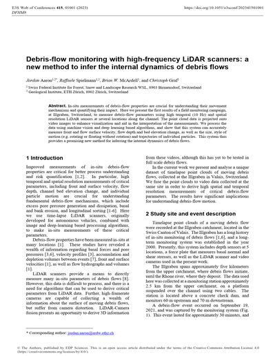
Debris-flow monitoring with high-frequency LiDAR scanners: A new method to infer the internal dynamics of debris flows
In-situ measurements of debris-flow properties are crucial for understanding their movement mechanisms and quantifying their impact. Here we present the first results of a field monitoring campaign, at Illgraben, Switzerland, to measure debris-flow parameters using high temporal (10 Hz) and spatial resolution LiDAR sensors at several locations along the channel. The point cloud data is projected onto video images to enhance visualization and aid in the interpretation of the measurements. We process the data using machine vision and deep learning based algorithms, and show that this system can accurately measure front and flow surface velocity, flow depth and bed elevation change, as well as the size, style of motion (e.g. rotating or floating without rotation) and trajectories of individual particles. This system thus provides a promising new method for inferring the internal dynamics of debris flows.
002
Analysis of superelevation and debris flow velocities at Illgraben, Switzerland
The forced vortex equation, based on the cross-stream inclination of a flow surface as it passes through a bend, is a common approach to estimating debris flow velocities. Here, we present the preliminary results of a study of superelevation and the correction factor k, used to adapt the forced vortex equation to debris flows, based on data from the Illgraben torrent in Switzerland. The definition of the radius of curvature, a factor in the calculation of superelevation velocities, is not found to exercise a large influence on the calculated velocities when using high resolution aerial images, with the choice of cross-section location and k-factor exercising a more significant influence. The k-factors found here fall within the range previously reported in the literature, ranging from approximately 1 to 7, and a previously suggested non-linear relationship with Froude numbers is evident in the dataset. Following the debris flow season of 2022, the study will be continued with additional debris flow events and the investigative methods will be extended to include high-resolution LiDAR sensors installed along the Illgraben torrent.
003
Particle size segregation and diffusion in saturated granular flows: Implications for grain sorting in debris flows
Sorting of rocks, boulders, and silt/sand-sized particles according to their size is a characteristic feature of debris flow deposits and is an active process during flow which significantly affects the mobility. The degree at which size sorting occurs in debris flows depends on the relative magnitudes of granular processes such as particle size segregation and diffusion. Since debris flows are fluid-saturated phenomena, accurate modelling of size sorting requires the understanding of the influence of fluids on these processes, which have not been systematically studied. Here, we present simulation results and the associated empirical expressions for particle size segregation and diffusion which take into account fluid effects due to buoyant and drag forces. These expressions are developed through scaling analysis of data obtained from coupled granular-fluid simulations of saturated bi-disperse mixtures under simple shear. We further show that using these scaling relationships, an existing segregation-diffusion continuum equation can be extended to model particle sorting in debris flows with various types of fluids.
004
Factors controlling bed and bank erosion in the Illgraben (CH)
Debris flows can grow greatly in size and hazardous potential by eroding bed and bank materials. However, erosion mechanisms are poorly understood because debris flows are complex hybrids between a fluid flow and a moving mass of colliding particles, bed erodibility varies between events, and field measurements are hard to obtain. Here, we (i) quantify the spatio-temporal patterns of erosion and deposition and (ii) identify the key controls on debris-flow erosion in the Illgraben (CH). We use a dataset that combines information on flow properties, antecedent rainfall, and bed and bank erosion for 13 debris flows that occurred between 2019 and 2021. We show that spatio-temporal patterns of erosion and deposition in natural debris-flow torrents can be highly variable and dynamic, and we identify a memory effect where erosion is strong at locations of strong deposition during previous flows and vice versa. We find that flow conditions and antecedent rainfall (affecting bed wetness) jointly control debris-flow erosion. We find statistically significant correlations between channel erosion/deposition and a wide range of flow conditions, including frontal flow depth, velocity, and discharge, and flow volume, cumulative shear stress and seismic energy, as well as antecedent rainfall. Overall, flow conditions describing the cumulative forces exerted at the bed during an event, such as cumulative shear stress and flow volume, best explain erosion. A shear-stress approach accounting for bed erodibility may therefore be applicable for modelling and predicting debris-flow erosion. This work can provide input for model development by identifying correlations of flow and bed conditions with erosion that models should oblige.
005
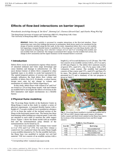
Effects of flow-bed interactions on barrier impact
Debris flow mobility is governed by complex interactions at the flow-bed interface. These interactions may cause flow bulking and increase in momentum. Both factors need to be considered for the design of barriers installed along the flow path. In this study, channelized debris flow over a wet erodible bed impacting a terminal flexible barrier is modelled in a 28-m-long and 2-m-wide flume facility with 20o slope inclination in Hong Kong. Tests with flow volumes of 6 m3 and 9 m3 overriding both erodible and non-erodible beds are conducted. The change in normalised flow energy over the erodible bed section, the change in flow momentum and the impact dynamics on the terminal barrier is assessed.
006
Keynote lecture. Constitutive modelling of phase transitions in granular soils
The use of numerical codes for simulating the propagation phase of fast landslides requires the definition of constitutive relationships suitable for the description of the mechanical behaviour of granular soils, under both solid and fluid conditions. In this paper, the authors briefly illustrate a constitutive modelling approach interpreting the material as a bi-phasic continuum, according to which the solid phase may behave like a solid, under quasi-static conditions, and a fluid, under collisional/dynamic conditions. The model presented seems to satisfactorily reproduce a series of results obtained by using a discrete element numerical code on mono and polydisperse granular specimens. The constitutive model has been implemented in a Material Point Method code to solve boundary value problems, in which strain rate large values are expected to influence the material response.
007
Numerical investigation of particle dynamic behaviours in geophysical flows considering solid-fluid interaction
Solid-fluid interaction vitally influences the flow dynamics of particles in a geophysical flow. A coupled computational fluid dynamics and discrete element method (CFD-DEM) is used in this study to model multiphase geophysical flow as a mixture of fluid and solid phases. The two non-Newtonian fluids (i.e., Bingham and Hershcel-Bulkley fluids) and water mixed with particles are considered in the simulation, while dry granular flow with the same volume is simulated as a control test. Results revealed that the solid-fluid interaction heavily governs the particle dynamic behaviours. Specifically, compared to dry case, particles in three multiphase cases are characterized by larger flow mobility and greater shear rate while smaller basal normal force. In addition, a power-law distribution with a crossover to a generalized Pareto Distribution is recommended to fit the distribution of normalized interparticle contact force.
008
Mass exchange between geophysical flows and beds: Idealised computational modelling using a Herschel-Bulkley rheology
A key mechanism by which geophysical flows evolve is mass exchange with the underlying bed, either by entraining material from the bed, or by depositing material. Although it is known that some consequences of these mass exchange processes include changes in the volume, momentum and local rheology of the flow, the circumstances under which specific changes occur are not well-established. Given the enormous number of competing mechanisms present in geophysical flows, it is not surprising that the state of the art for modelling entrainment is essentially still empirical. In this study, we implement a Herschel-Bulkley (non-Newtonian) rheology into an existing open-source Smoothed Particle Hydrodynamics solver (DualSPHysics). This rheology can reasonably represent clay-rich flows, typical of those observed in the French Prealps. We hence undertake a highly-idealised, quantitative investigation of entrainment mechanisms for flows overriding non-fixed beds. For the beds, we vary the yield stress and the depth. Preliminary results reveal a rich variety of behaviours that can be obtained for different bed properties, including both acceleration and deceleration of the flow material. These mechanisms are reminiscent (but not identical) of observations from other studies where geo-materials were used.
009
Critical states observed in triaxial compression tests on volcanic pumice soil related to debris flow in the 2008 Iwate-Miyagi Nairiku Earthquake
The Iwate-Miyagi Nairiku Earthquake (M7.2) that occurred on June 14, 2008, caused a slope failure in Dozo-zawa River near the summit of Mt. Higashi-Kurikoma. The debris flow caused by the slope failure flowed for about 10 km and took the lives of 7 people. The mechanisms of the slope failure and long-distance debris flow have not yet been well understood. In this study, a series of triaxial compression tests was conducted using a highly crushable pumice soil collected from the collapsed area, and shear behavior and particle breakage were discussed. Both reconstituted specimens and intact specimens showed contractancy and reached critical states that implies high flow potential. However, intact specimens preserved looser structure during consolidation and showed stronger contractancy during shearing than the reconstituted specimens, due to their natural soil structure. Significant particle breakage was observed in the tests with reconstituted specimens.
010
Entrainment maps considering hydrological conditions for mass movement runout modelling: Application to debris-flow bulking at Pizzo Cengalo
Debris flows entrain sediments and water along their flow path and grow significantly in size. Because the entrainment process isn’t well understood and data is rare, hazard and risk assessment with numerical models is challenging. It is known, however, that both for debris flows and rock avalanches, interstitial pore water in flow path substrate can cause increases in pore water pressures when overridden by the flow, which enhances erosion. The entrained water likely also plays a role in the process transition from rock avalanche to debris flow, like in the Pizzo Cengalo event in 2017. We present a framework for producing entrainment maps serving as an input for runout modelling, here illustrated using RAMMS. The entrainment maps consist of spatially-distributed entities with properties such as max erosion depth, and soil water content inferred from land cover and lithology maps. This study serves as a basis for producing duration curves of subsurface water available for entrainment and include it into the entrainment maps. Such hydrologically-informed entrainment maps will be useful to assess the probability of certain runout distances.
011
The influence of particle size on the spread distance and angle of friction of granular materials
To produce a hazard map and thus provide mitigation measures against natural catastrophic events such as landslides, avalanches, and debris flows, it is necessary to determine the spread distance of such flows. There is a well-documented relationship between the angle of friction and the debris flow volume, allowing one to determine the possible distance a debris flow can travel. However, the effect of mean particle size (d50) and the sorting coefficient (Sc) on the final spread distance (Df) has received mere attention. In this study, a mini conical-shaped mould was used to measure the final spread distance (Df) and angle of friction (αf) for various dry granular material samples both in air and in water. Experimental results indicated that a granular material sample with a smaller d50 travel a longer distance compared to a sample with a higher d50. However, a sample with a smaller d50 results in a smaller angle of friction than the one with a higher d50. Conversely, a well-sorted sample has a smaller spread distance and larger angle of friction. Results also indicated that the spread distance in air is slightly larger and the angle of friction is slightly smaller than in water.
012
Triggering-runout modelling of rainfall-triggered debris flows: A case study in the Campania region, Italy
Debris flows are unpredictable phenomena, listed among the hugest natural hazards, since they can cause important damages to humans and structures. Rainfall can trigger this type of movements, as it provokes the pore water pressure increasing, and so the soil strength reduction. The phenomenon modelling is a key aspect to predict and prevent damages. This article shows an approach for triggering and runout analysis: triggering is studied through an infinite slope stability model of rainfall-triggered shallow landslides, while runout is modelled using a depth-averaged numerical method, which replace the real heterogeneous flow with an equivalent homogeneous fluid. The work focuses the attention to events characterized by multiple triggering zones and releases converging on the same area, whose complexity is represented by the time- and space-distribution of the different flows. The proposed approach is applied to an event that hit part of the Campania region, Italy, in 1998, causing several damages. Two rheological laws are considered and compared for the analysis. The back-analysis allows the calibration of the rheological parameters and validation of the method. Results are discussed to identify the most suitable rheology for the benchmark event.
013
A robust method to identify the occurrence of a runoff-generated debris flow
Debris flows generated by rainfall runoff can occur in rocky alpine landscapes and burned steeplands. Runoff-generated debris-flow events are commonly composed of a series of dense granular surge fronts separated by water-rich flows. Owing to this intra-event variability in flow composition and mechanics, post-event interpretations of preserved sedimentary deposits, or lack thereof, can result in a dizzying mix of interpretations that range from clearwater flow to debris flow. Accurate identification of the presence or absence of a debris flow during a runoff event is critical for building empirical models used to predict likelihood of debris-flow occurrence, rainfall thresholds, and flow properties. Here, we propose a simple, quantitative method to identify the occurrence of a runoff-generated debris flow, based on a dimensionless discharge Q* calculated as the ratio of the peak event discharge Qp to the theoretical maximum clearwater runoff rate Qw. Using a preliminary compilation of Q* values from floods and runoff-generated debris flows, we find 98% of floods have Q* values < 1.6, whereas 91% of debris flows have Q* values greater than 1.6. Estimating Q* is typically straightforward as part of standard post-event reconnaissance if suitable rainfall estimates are available, and appears to be a robust indicator that runoff-generated debris flows traversed a particular portion of a valley network.
014
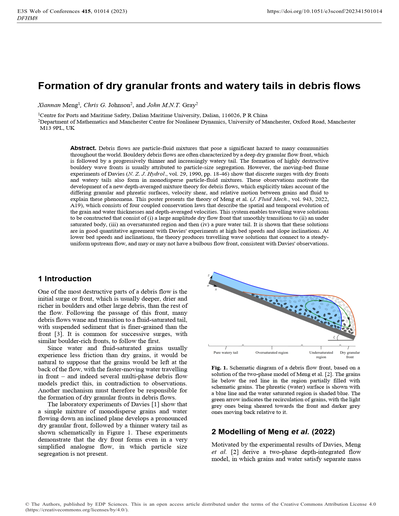
Formation of dry granular fronts and watery tails in debris flows
Debris flows are particle-fluid mixtures that pose a significant hazard to many communities throughout the world. Bouldery debris flows are often characterized by a deep dry granular flow front, which is followed by a progressively thinner and increasingly watery tail. The formation of highly destructive bouldery wave fronts is usually attributed to particle-size segregation. However, the moving-bed flume experiments of Davies (N. Z. J. Hydrol., vol. 29, 1990, pp. 18-46) show that discrete surges with dry fronts and watery tails also form in monodisperse particle-fluid mixtures. These observations motivate the development of a new depth-averaged mixture theory for debris flows, which explicitly takes account of the differing granular and phreatic surfaces, velocity shear, and relative motion between grains and fluid to explain these phenomena. This poster presents the theory of Meng et al. (J. Fluid Mech., vol. 943, 2022, A19), which consists of four coupled conservation laws that describe the spatial and temporal evolution of the grain and water thicknesses and depth-averaged velocities. This system enables travelling wave solutions to be constructed that consist of (i) a large amplitude dry flow front that smoothly transitions to (ii) an under saturated body, (iii) an oversaturated region and then (iv) a pure water tail. It is shown that these solutions are in good quantitative agreement with Davies’ experiments at high bed speeds and slope inclinations. At lower bed speeds and inclinations, the theory produces travelling wave solutions that connect to a steady-uniform upstream flow, and may or may not have a bulbous flow front, consistent with Davies’ observations.
015
A dilatant two-phase debris flow model with erosion validated by full-scale field data from the Illgraben test station
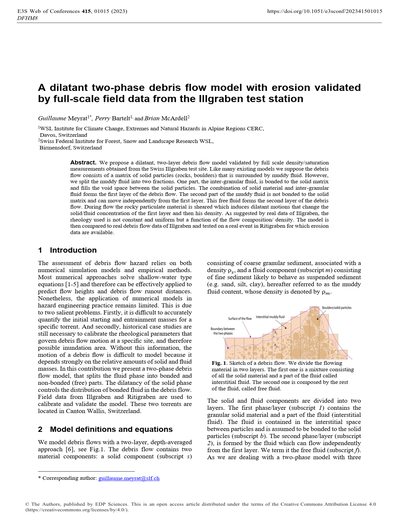
We propose a dilatant, two-layer debris flow model validated by full scale density/saturation measurements obtained from the Swiss Illgraben test site. Like many existing models we suppose the debris flow consists of a matrix of solid particles (rocks, boulders) that is surrounded by muddy fluid. However, we split the muddy fluid into two fractions. One part, the inter-granular fluid, is bonded to the solid matrix and fills the void space between the solid particles. The combination of solid material and inter-granular fluid forms the first layer of the debris flow. The second part of the muddy fluid is not bonded to the solid matrix and can move independently from the first layer. This free fluid forms the second layer of the debris flow. During flow the rocky particulate material is sheared which induces dilatant motions that change the solid/fluid concentration of the first layer and then his density. As suggested by real data of Illgraben, the rheology used is not constant and uniform but a function of the flow composition/ density. The model is then compared to real debris flow data of Illgraben and tested on a real event in Ritigraben for which erosion data are available.
016
A novel approach to measuring pore fluid sediment concentrations of debris flows in a volcanic torrent
Pore fluid in a debris flow is not fully understood, despite its contribution to the fluidity of the debris flow. To observe sediment concentrations of the pore fluids in debris flows, we established a novel monitoring system in a volcanic catchment, in southern Japan. An observation culvert, 1.0 m in width, 1.5 m in height and 2.0 m in length, was placed along the stream bank. An intake covered by a grating was equipped on the side of the culvert so that only pore fluid of debris flows was led inside. Measurements of dielectric permittivities were conducted within the culvert and used for the calculation of sediment concentrations of the fluid. The sediment concentrations of the pore fluid were successfully measured for natural debris flows. The preliminary observation revealed that the volumetric sediment concentration of pore fluid varied from approximately 5 to 69 %, which were slightly smaller or similar to those of the entire debris flows. Successive occurrences of debris flow caused decreases in the sediment concentration of the pore fluids with each surge.
017
Multi-component avalanches for rock- and ice-falls to potential debris flow transition modelling
Rock/ice avalanches are complex gravitational flows involving three important physicalprocesses: entrainment, phase-changes, and flow transitions. The basic complexity of modelling rock/ice avalanches lies in the fact that the flow is a mixture of rock, ice, water, snow, soil sediments. The interaction of these components can lead to flow transitions which is difficult to model with simplified flow rheologies. For example, a flow initially composed of rocks and ice can transition into a long-runout debris flow, dependent on the entrainment of water, water-saturated sediments and/or snow. The dynamic behaviour of rock/ice avalanches is therefore highly difficult to predict because the flow mixture is dependent on the hydrological and geomorphological properties along the avalanche track. These properties can vary from year to year but even from season to season. The problem is intensified by the fact that frictional shearing can produce enough heat energy to melt ice and snow, leading to additional water in the flow. In this contribution, we present a new RAMMS module specifically designed to simulate single- and multicomponent avalanches of rock, ice, water, snow, and ice. The rheology of the flow is treated by using the concept of component activation energy. The model includes both snow and sediment/water/ice entrainment modules. A unique feature of the model is that it tracks the temperature of the rock, ice and water phases and therefore can treat phase changes. We apply the model on the Chamoli case-study to highlight the potential and present limitations of the model..
018
Debris flow susceptibility mapping in Colorado Front Range, USA: A comparison of physics-based and data-driven approaches
This study used an inventory of debris flow triggered by a storm event in Colorado Front Range as an example to compare the capability of data-driven and physics-based approaches for regional-scale debris flow susceptibility mapping (LSM). Nine debris flow contributing factors were collected for the present study based on the availability of geophysical data in the study area. These contributing factors represent hillslope geometries, surface hydrology, and soil conditions. For the physics-based approach, the infinite slope model was used to directly determine the debris flow susceptibility for the study area by calculating the factor of safety (FS) based on parameters derived from geophysical data. For the data-driven approach, an artificial neural network (ANN) was developed to predict debris flow susceptibility for the study area by learning relationships from the contributing factors using the debris flow inventory. The results showed that both physics-based and data-driven models predicted debris flow susceptibility in the study area with relatively high accuracy; the data-driven approach outperformed the physics-based approach as it could extract complex features which the physics-based approach did not consider.
019
Keynote lecture. Granular flows
Our understanding of granular flows has progressed considerably over the past two decades. In this talk, I will first review the advances made in the rheology of dense granular media based on the concept of pressure-imposed rheology, discussing the different regimes, from viscous to inertial. I will also illustrate how these rheological descriptions can be used in a two-phase flow approach to model more complex flow configurations, at least in simple small scaled experiments mimicking granular avalanche flows. Can these advances help describe and predict debris flows, is not an easy question, which I will try to discuss by pointing out the limitations and robustness of the rheological models.
020
Effects of debris-flow and bed composition on erosion and entrainment
Erosion and entrainment of material by debris flows determine debris-flow volume growth and therefore hazard potential. Recent advances in field, laboratory, and modelling studies have distilled two driving forces behind debris-flow erosion; impact and shear forces. A third factor influencing the (relative) importance of these forces is the viscosity and abundance of the interstitial fluid in the debris flow and the bed. However, how erosion and these forces depend on the composition of the debris flow itself and the composition of the bed remains unclear. Here, we present results of small-scale flume experiments with a loosely packed erodible bed that highlight the far-reaching effects of debris-flow and bed composition on erosion processes and magnitude. We quantify the effects of gravel, clay, and solid fraction in the debris flow on bed erosion. In addition, we quantify the effects of water and clay content of the unconsolidated bed on erosion by a debris flow. We show that debris flow erosion increases linearly when the gravel fraction of a debris flow is increased, which is linked to an increase in both impact and shear forces. We find that debris flow erosion, and the related forces, are non-linearly impacted by the clay and water content of the debris flow and those of the bed. For both the clay content of the debris flow and the bed, an optimum in erosion exists around a specific clay percentage that does not directly relate to an optimum in either shear or impact forces. When the water content of the bed and/or the debris flow is increased, erosion becomes largest when supersaturated conditions occur. These conditions are unrelated to the magnitude of the two erodible forces. This shows that both clay and water content affect erosion by affecting the transfer of pore pressures from the debris flow to the bed. We can therefore conclude that impact and shear forces dictate debris flow erosion in most cases but that their (relative) importance is significantly altered by the means and effectivity of pore pressure transfer from the debris flow to the bed. The latter is highly influenced by the viscosity and abundance of the interstitial fluid of the debris flow and the composition of the bed.
021
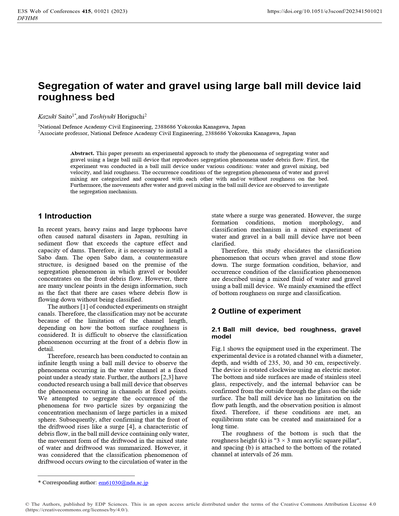
Segregation of water and gravel using large ball mill device laid roughness bed
This paper presents an experimental approach to study the phenomena of segregating water and gravel using a large ball mill device that reproduces segregation phenomena under debris flow. First, the experiment was conducted in a ball mill device under various conditions: water and gravel mixing, bed velocity, and laid roughness. The occurrence conditions of the segregation phenomena of water and gravel mixing are categorized and compared with each other with and/or without roughness on the bed. Furthermore, the movements after water and gravel mixing in the ball mill device are observed to investigate the segregation mechanism.
022
Laboratory investigation of the effects of grain size on the dynamics of debris flows: Measurement of pore fluid pressure in an open channel
The dynamics of debris flow depend on internal stress components, such as particle–particle stress, the stress exerted by pore water, and interactions between particles and pore water. Although dominant internal stress components depend on the grain size composition, the effects of grain size on the dynamics of debris flow are not fully understood. To investigate the effects of grain size on the dynamics of debris flows, pore fluid pressures were measured in an open channel experiment. In the experiment, monodisperse debris flows were triggered for five different grain sizes: 0.2, 0.8, 1.3, 2.2, and 2.9 mm. The pore fluid pressures in debris flows of 0.2 mm grains had larger excess pressures over the hydrostatic pressure, and were close to the total normal stress, while those of other grain sizes had smaller excess pressures and were relatively close to the hydrostatic pressure. Comparing the measured friction factors and theoretical ones for stony debris flows, particle–particle stress dominated in debris flows, except for 0.2 mm grains, and the measured excess pore pressures could be explained by the Reynolds stress of pore fluid due to shear by particles in laminar motion. By contrast, particle–particle stress did not dominate in debris flows of grain size 0.2 mm, and a large portion of the particles was in suspension affected by turbulence. These differences in flow dynamics may correspond to the flow transition from laminar to turbulent flow described by the threshold of relative flow depth, which is the ratio of the flow depth to grain size.x
023
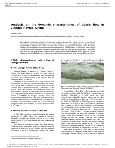
Analysis on the dynamic characteristics of debris flow in Jiangjia Ravine, China
Dynamic characteristics determine the mobility of debris flow and are also key to hazard risk assessment. However, the dynamic process of natural debris flow is very complex. Based on the systematic analysis of the field observation data of 93 debris-flow events at Jiangjia Ravine (Yunnan, China), this study attempts to investigate the dynamic mechanisms and sources of flow resistance of debris flow. The Jiangjia Ravine debris flows are almost completely liquefied, indicating that grain contact friction plays a negligible role. Flow regime analysis shows that the flow regimes of the Jiangjia Ravine debris flows varie from viscous to inertial. The fluid viscous effect and particle collisions may be the main sources of flow resistance.
024
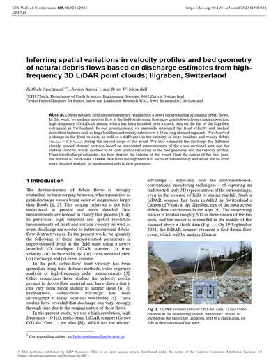
Inferring spatial variations in velocity profiles and bed geometry of natural debris flows based on discharge estimates from high-frequency 3D LiDAR point clouds; Illgraben, Switzerland
More detailed field measurements are required for a better understanding of surging debris flows. In this work, we analyze a debris flow at the field-scale using timelapse point clouds from a high-resolution, high-frequency 3D LiDAR sensor, which has been installed over a check dam on the fan of the Illgraben catchment in Switzerland. In our investigations, we manually measured the front velocity and tracked individual features such as large boulders and woody debris over a 25 m long channel segment. We observed a change in the front velocity as well as a difference in the velocity of large boulders and woody debris (vboulder ≈ 0.6 vwood) during the second surge of the event. We also estimated the discharge for different closely spaced channel sections based on automated measurements of the cross-sectional area and the surface velocity, which enabled us to infer spatial variations in the bed geometry and the velocity profile. From the discharge estimates, we then derived the volume of this event. Over the course of the next year, the amount of field-scale LiDAR data from the Illgraben will increase substantially and allow for an even more detailed analysis of fundamental debris-flow processes.
025
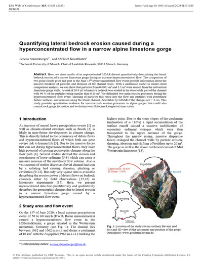
Quantifying lateral bedrock erosion caused during a hyperconcentrated flow in a narrow alpine limestone gorge
Here, we show results of an unprecedented LiDAR dataset quantitatively determining the lateral bedrock erosion of a narrow limestone gorge during an extreme hyperconcentrated flow. The comparison of two point clouds prior and post to the June 15th hyperconcentrated flow event provide information about the massive breakout of particles and abrasion of the channel walls. With a multiscale model to model cloud comparison analysis, we can show that particles from 0.0001 m3 and 3.5 m3 were eroded from the subvertical limestone gorge walls. A total of 20.9 m3 of massive bedrock was eroded in the observable part of the channel with 90 % of the particles being smaller than 0.15 m3. We delimited two main erosion processes during the hyperconcentrated flow event: shearing of particles that reach into the flow and particles with predefined failure surfaces, and abrasion along the whole channel, detectable by LiDAR if the changes are > 3 cm. This study provides quantitative evidence for massive rock erosion processes in alpine gorges that could also control rock gorge formation and evolution over Holocene/Lateglacial time scales.
026
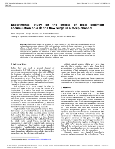
Experimental study on the effects of local sediment accumulation on a debris flow surge in a steep channel
Debris flow surges can terminate in a steep channel of > 15°. However, the termination process and mechanisms remain unknown. This study conducted small-scale flume experiments to investigate the effects of local sediment accumulation on debris-flow surges in a steep channel. The experiments demonstrated that local accumulation of bed sediment terminates a debris flow surge owing to abrupt changes in bed gradients and infiltration of debris flow interstitial water. Subsequently, the mass of the terminated debris-flow surge and bed sediment began to move, triggering a larger debris-flow surge. This result suggests that predicting the scale of a debris flow arriving downstream requires measuring the distribution of bed sediment in the debris flow initiation zone.
027
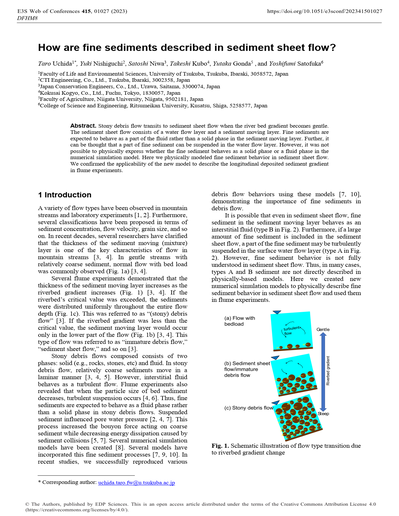
How are fine sediments described in sediment sheet flow?
Stony debris flow transits to sediment sheet flow when the river bed gradient becomes gentle. The sediment sheet flow consists of a water flow layer and a sediment moving layer. Fine sediments are expected to behave as a part of the fluid rather than a solid phase in the sediment moving layer. Further, it can be thought that a part of fine sediment can be suspended in the water flow layer. However, it was not possible to physically express whether the fine sediment behaves as a solid phase or a fluid phase in the numerical simulation model. Here we physically modeled fine sediment behavior in sediment sheet flow. We confirmed the applicability of the new model to describe the longitudinal deposited sediment gradient in flume experiments.
028
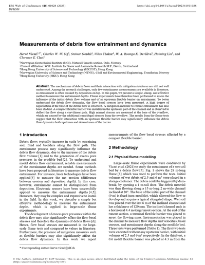
Measurements of debris flow entrainment and dynamics
The mechanisms of debris flows and their interaction with mitigation structures are still not well understood. Among the research challenges, only few entrainment measurements are available in literature, as entrainment is often masked by deposition on top. In this paper, we present a simple, cheap, and effective method to measure the entrainment depths. Flume experiments have therefore been performed to assess the influence of the initial debris flow volume and of an upstream flexible barrier on entrainment. To better understand the debris flow dynamics, the flow basal stresses have been measured. A high degree of liquefaction at the base of the debris flow is observed. A mitigation measure to reduce entrainment has also been studied. A compact flexible barrier was installed in the upstream part of the channel and is observed to deflect the flow along a curvilinear path. High normal stresses are measured at the base of the overflow, which are caused by the additional centrifugal stresses from the overflow. The results from the flume tests suggest that the flow interaction with an upstream flexible barrier may significantly influence the debris flow dynamics both upstream and downstream of the barrier.
029
Effect of Including Sand Component in a Debris Flow on Concentration of Coarser Particles at the Flow Front
We conducted flume experiments for a debris flow consisting of coarser particles, finer particles and sand, focusing on the concentration of coarser particles at the flow front. Our experimental results revealed that the concentration of coarser particles at the flow front using sediment mixture with sand was less than that without sand. This may be because including of sand component in the material contributed to be a smaller averaged interstice between particles in the flow layer and a smaller averaged particle size. These may lead to reduce the falling volume of sand or finer particles and dispersion pressure for the rise of coarser particles, respectively, resulting in the inhibition of inverse grading formation. Our experimental results also suggested that the changing trend in the proportion of finer particles depended on the relationship between their particle size and the average particle size of the flow. These are consistent with our previous experimental results using material without sand. This consistency suggested that for the concentration of coarser particles at the flow front, the behavior of the sand component can be considered in the same manner as other coarser-sized components.
030
Fines-controlled drainage in just-saturated, inertial column collapses
The wide particle size distributions, over several orders of magnitude, observed in debris flows leads to a diverse range of rheological behaviours controlling flow outcomes. This study explores the influence of different scale grains by conducting subaerial, fully saturated granular column collapse experiments with extreme, bimodal particle size distributions. The primary particles were of a size where their behaviour was controlled by their inertia while a suspension of kaolin clay particles within the fluid phase acts at spatial scales smaller than the pore space between the primary particles. The use of a geotechnical centrifuge allowed for the systematic variation of gravitational acceleration, inertial particle size and the degree of kaolin fines. Characteristic velocity- and time-scales of the acceleration phase of the collapse were quantified using high-speed cameras. Comparing tests containing fines to equivalent collapses with a glycerol solution mimicking the enhanced viscosity but not the particle behaviour of the fines, it was found that all characteristic dynamic quantities were dependent on the degree of fines, the system size, the grain fluid-density ratio and the column– and grain-scale Bond and Capillary numbers. We introduce a fine-scale Capillary number showing that, although surface tension effects at the column scale are negligible, fines do control the movement of fluid through the pore spaces.
031
Simulations of non-stationary flows of dry granular material along an inclined chute
In this work, the signals generated by grain-to-base multiple impacts of three different granular materials flowing along an inclined chute and characterized by unsteady-state conditions are investigated through the discrete element method (DEM). The effect of different grain-size and angularity of the grains are taken into account. Various instants of the flows are studied, focusing in particular on the analysis of the signal produced by the passage of the material on a portion of the base of the chute, and on the study of the motion of the particles close to the base. The numerical results allow us to have an insight into the characteristics of the flows and to explain the behavior of the granular material at the contact with the base.
032
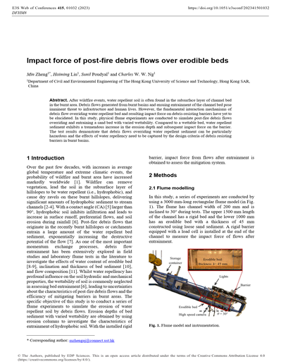
Impact force of post-fire debris flows over erodible beds
After wildfire events, water repellent soil is often found in the subsurface layer of channel bed in the burnt area. Debris flows generated from burnt basins and ensuing entrainment of the channel bed pose imminent threat to infrastructure and human lives. However, the fundamental interaction mechanisms of debris flow overriding water repellent bed and resulting impact force on debris-resisting barriers have yet to be elucidated. In this study, physical flume experiments are conducted to simulate post-fire debris flows overriding and entraining a sand bed with varied wettability. Compared to a wettable bed, water repellent sediment exhibits a tremendous increase in the erosion depth and subsequent impact force on the barrier. The test results demonstrate that debris flows overriding water repellent sediment can be particularly hazardous and the effects of water repellency need to be captured by the design criteria of debris resisting barriers in burnt basins.
Experiments and Modeling
001
Small-scale study of Debris-Flows Interactions with a Lateral Debris Basin and Crossings: The Manival Torrent case study
Small-scale models are useful tools to study the interactions between debris flows and structures and channels. Small-scale modelling of debris flows remains however complicated because of the complex rheology and scaling challenges of these geophysical processes. An on-going study of a debris basin and the downstream channel where two fords and a bridge are located is presented in this extended abstract. The studied torrent is the Manival catchment, located near Grenoble in France. We present the catchment features, the scientific questions studied, some preliminary calibration results describing the mixtures used to model debris flows as well as results from three debris-flood and two debris-flow runs. In essence, the model highlighted that the structure enable a large share of the bedload transport to pass downstream. Debris flows can be more or equally trapped depending on their rheology which controls the surges dynamics and the deposition slope in the debris basin.
002
Simulations of the occurrence of runoff-generated debris flows by means of hydrological models in headwater rocky basins
The simulation of the occurrence of the runoff-generated debris flows can be approached by means of hydrological models. In this work, we show that a rainfall-runoff model designed for the simulation of runoff in headwater rocky basins can capture both the transit timing of the first debris-flow surge and its hydrograph. We successfully compared the stage hydrograph of debris flows with that of the simulated runoff in two headwater rocky basins of Dolomites.
003
The Rosetta Stone Project – Integrating experimental results on debris flow mechanics across the scales: Next results
We present the combined efforts of a research network designed to address the many challenges in the experimental modelling of debris flow phenomena. The approach has been to use apparatuses of different functional arrangement and at different scale with identical and commonly sourced flow materials from the highly idealised (dry, coarse and uniform) to the highly complex (well graded, segregating, fluid saturated). Here we briefly present some key findings of the network and point to the research questions that are currently being addressed. This complementary view of experimental debris flows helps to constrain methodological artefacts/scale effects and to identify key processes responsible for the diverse appearance and often high mobility of debris flows.
004
Keynote lecture. The planar setup: A window through the complex interactions in granular flows
Granular flows are a complex process, involving a wide range of grain sizes, materials, varied viscous fluids, among others. For this reason, the simulation of granular flows requires a certain level of simplification, allowing the isolated study of its governing variables and extending the global observations to field events. Here, we present the planar setup as an alternative for studying simplified processes associated to granular flows. The planar setup consists of two windows separated by a thin gap and enclosing a granular assembly. We present two examples where the planar setup is adapted for the study of the competing action of segregation and disaggregation in a fractured grain under shear flow, and for the study of the stability scenarios of a flow impacting a permeable obstacle. The close visualization of the kinematics at the particle scale provides an ideal opportunity for describing the mechanisms behind the grain disaggregation or controlling the obstacle stability. Both examples highlight the advantages of the planar setup for the study of granular flows.
005
Impact of a dry granular flow against a rigid wall: MPM simulations with a new constitutive approach
The dynamic interaction between granular flowing masses and obstacles is a very complex phenomenon involving large displacements and high strain rates. To simulate the event in a continuum-based framework both advanced numerical tools and constitutive relationships are required. In this work, the impact of a dry granular mass against a rigid wall is numerically simulated using the open-source Material Point Method code ANURA3D, while the constitutive model proposed by Marveggio et al., 2021 is adopted for the granular mass. The model accounts for rate and grain packing dependence, which have been shown to be crucial to reproduce the propagation of compression and rarefaction waves inside the mass. The model is capable of reproducing “solidification” and “liquefaction” phenomena observed in the DEM impact tests results already available in the literature.
006
Laboratory experiments to analyse the influence of bridge profiles on debris-flow impact forces
Debris-flow impact plays a significant role in the failure of bridges in mountainous areas posing a risk to human life and leading to high reconstruction costs. The aim of this study is to measure and quantify the frontal impact forces of debris flows on bridge superstructures based on laboratory experiments with a special regard to the comparison of two different bridge profiles and the presence / absence of a bridge pier. To this end, we conducted 20 experiments, measuring the frontal impact forces on the bridge superstructure with two 3-axis force sensors at the abutments of the miniature bridge. We found that the type of the superstructure does have an influence on the magnitude of the frontal impact forces.
007
Laboratory experiments to analyse the influence of bridge profiles on debris-flow impact forces
The openFOAM solver faDebrisFOAM was recently developed to simulate debris flows with the finite area method. This new solver includes, among other capabilities, a variable density for the solid-liquid mixture, erosion and deposition processes, and a terrain modification algorithm. To test the performance of this new solver, we simulate the debris flow event that occurred in the Crucecita alluvial fan on the 13th May 2017 in the Atacama Desert, Chile. Thanks to pre- and post-event topographies, we have an accurate measure of the morphological changes that took place. Comparing the field data and our numerical model results shows that faDebrisFOAM can reproduce the main flooded, eroded, and deposited areas. Once the model is calibrated, we study the behavior of the terrain modification algorithm. Finally, we discuss the advantages of using this model to reproduce erosion and deposition processes together with changing rheologies for a debris flow event.
008
Hydraulic model test on channel shifting and yielding woody debris on the fan after sediment disaster in the past
The re-movement of sediment and woody debris in torrents after huge sediment transport in the past could cause new flood and sediment disasters due to heavy rainfall events. However, it is not clear how re-movement of logs effects on bed variations such as bars and river channel divergence. In present study, hydraulic model tests were carried out referring to the magnitude of floods, that was over the plan size, in Tottabetsu River basin in August in 2016. These tests include different magnitudes of flood, suppling logs from bed/side bank erosion, and existence of sabo facilities. The key results were as follows: The presence of logs by bed/side bank erosions influences on the patterns of flows and sediment transport, because deposition of logs affects formation of bars. Difference of the magnitudes of the floods affects the activeness of the interaction between logs and sediment transport. In additions, the locations and slits of the sabo dam need to consider hydraulic conditions and characteristics of woody debris for appropriate control of sediment and woody debris.
009
Pilot study to explain runout distances of debris flow and immature debris flow considering depositing rate
In Japan, many debris flows and sediment-laden floods cause serious damage to human life and property. Effective measures require high-accuracy reproduction and prediction of runout distance (bed variation reach) via numerical simulations. One possible method to increase the accuracy of numerical simulation results involves reviewing the methods used to evaluate depositing rate for flows that contain many different sizes of sediments. This study performed experiments using an artificial channel and high-speed cameras to identify parameters that govern depositing rate. The channel implemented exhibited a change in slope point; thus, the slope of the upper reach differed from the slope of the lower reach. The experiments showed that the equation representing depositing rate is closely related to flow velocity. Additionally, the equation of depositing rate can be determined if other parameters are consistently considered.
010
Object Impacted and Transported by Dry Granular Flow: 3D MPM-SDEM
Granular geophysical flows pose a significant threat to human lives and infrastructure in mountainous regions globally. Property and victims impacted by these flows often get carried away and buried. Quickly locating the potential location of victims is critical for post-disaster recovery and rescue. However, the trajectory of object impacted by granular flows is difficult to predict because of the scale disparity between the sizes of granular particles and the object being transported. To deal with this multi-scale problem, a continuum-discrete solver, specifically the material-discrete element method (MPM-SDEM), was developed to simulate the trajectory of a cube (the object) impacted by a dry granular flow. Simulated results are used to understand the trajectory of objects under different flow and impact dynamics.
011
Numerical Simulation Reflecting Buildings in Area Damaged by Debris flow
More than 80% of average annual precipitation in South Korea occurs between June and September owing to heavy rainfall and typhoons in summer, and its land is vulnerable to mountain disasters (landslides and debris flow) as 63% of it is mountainous areas. In this study, an area damaged by debris flow in Wondeok-eup, Samcheok-si, Gangwon-do, Korea under the influence of Typhoon Mitag in 2019 was surveyed and numerical modeling was performed. Topographic data were created using the 5m grid DEM derived through the field survey data and GIS technique as well as the building data of the damaged area, and debris flow modeling was performed using the Hyper KANAKO model. A comparison with the inundation trace map showed that the simulation results based on topographic data that reflected buildings exhibited similar flow patterns and characteristics to the actual damage.
012
Evaluation of a method to calculate debris-flow volume based on observations of flow depth
The volume of a debris flow is a critical parameter in hazard analysis, yet accurate estimates of volume are often unavailable due to mixing with larger rivers at the downstream end of alluvial fans. We describe a method to calculate the volume of debris flows using flow depth data collected at a check dam, using a Manning friction relation to describe the velocity of the debris flow as a function of flow depth, and the geometry of the channel cross section. The method is evaluated using a published data set from the USGS debris-flow flume where event volume and stage information have been accurately measured, and results in volume estimates either somewhat smaller than or up to 50% larger than observed volumes. We further demonstrate the method to single-surge and a multiple-surge debris flows observed at Illgraben.
013
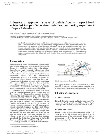
Influence of approach shape of debris flow on impact load subjected to open Sabo dam under an overturning experiment of open Sabo dam
Recently high intensity rainfall disaster induces some structural failure of steel pipe open Sabo dam. To prevent such failure of the dam, a new design concept is necessary at the severe load exceeding the present design load. However, influence of debris flow impact load on steel pipe open Sabo dam is not clear to make a design load. The study experimentally approaches a vertical load distribution shape and its time history based on comparison with a wedge approach shape or a front boulder concentrated shape. The load and moment action of a front boulder concentrated shape debris flow is greater than that of a wedge approach shape. Mechanism making the difference is made clear by observation of vertical detail measurement of impact load.
014
Statistical Modelling of Sediment Supply in Torrent Catchments of the Northern French Alps
The ability to understand and predict sediment transport in torrent catchments is a key element for the protection and prevention against the associated hazards. In this study, we collected data describing sediment supply at 100 torrential catchments in the Northern French Alps. These catchments have long records of past events and sediment supply due to debris deposition basin management enabling estimation of sediment supply frequency. The mean annual, the 10-year return period and the reference volume (i.e. the 100-year return level or the largest observed volume) of sediment supply were derived for studied torrents. We examined the relationships between sediment supply volumes and several explanatory variables using multivariate statistical analyses. Several predictive models were developed in order to estimate the sediment supply in torrents that are not equipped with sedimentation structures.
015
Coupling Depth-Averaged and 3D numerical models to study debris flow: Saint-Vincent event
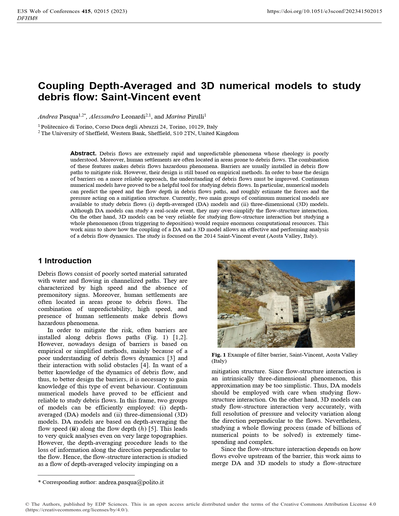
Debris flows are extremely rapid and unpredictable phenomena whose rheology is poorly understood. Moreover, human settlements are often located in areas prone to debris flows. The combination of these features makes debris flows hazardous phenomena. Barriers are usually installed in debris flow paths to mitigate risk. However, their design is still based on empirical methods. In order to base the design of barriers on a more reliable approach, the understanding of debris flows must be improved. Continuum numerical models have proved to be a helpful tool for studying debris flows. In particular, numerical models can predict the speed and the flow depth in debris flows paths, and roughly estimate the forces and the pressure acting on a mitigation structure. Currently, two main groups of continuum numerical models are available to study debris flows (i) depth-averaged (DA) models and (ii) three-dimensional (3D) models. Although DA models can study a real-scale event, they may over-simplify the flow-structure interaction. On the other hand, 3D models can be very reliable for studying flow-structure interaction but studying a whole phenomenon (from triggering to deposition) would require enormous computational resources. This work aims to show how the coupling of a DA and a 3D model allows an effective and performing analysis of a debris flow dynamics. The study is focused on the 2014 Saint-Vincent event (Aosta Valley, Italy).
016
Keynote lecture. A general two phase depth integrated model considering pore water pressure and dewatering
Debris flows can be considered a type of landslide with large velocities and long run-out distances. There are many types of debris flows, depending on the properties of the solid and fluid components of the mixture. The triggering and propagation of debris flows can be studied using a single 3D mathematical model. The computational cost can be very high because of their length, and depth-integrated models provide a good combination of accuracy and cost. Both types of models can be combined in the analysis, using 3D models for initiation and at singular points where more accuracy is wanted. As in a chain where the strength is never higher than that of the weaker link, we have to ensure that all the models are accurate enough in a joint model. This paper deals with a new depth-integrated model which can take into account the changes caused by dewatering in a debris flow.
017
Granular column collapse: The role of particle size polydispersity on the velocity and runout
Geophysical mass flows involve particles of different sizes, a property termed polydispersity. The granular column collapse is a simplified experiment for studying transitional granular flows. Our research focuses on the role that polydispersity has on the velocity and runout distance of dry and immersed granular columns, undergoing a numerical and experimental study. Our results highlight that polydispersity does not have a strong effect on the collapse of dry columns. On the contrary, the collapse sequence of immerse granular columns strongly depend on the polydispersity level.
018
Chute flows of dry granular media: Numerical simulations by a well-posed multilayer model and comparisons with experiments
Debris flows and avalanches are dangerous natural phenomena, characterized by the gravity-driven motion of granular media immersed in a fluid. For an appropriate hazard assessment or disaster mitigation by scenario investigation, it is crucial to capture the underlying dynamics of the granular solid phase. For this purpose, a multilayer depth-averaged approach represents a promising and computationally efficient tool over fully three-dimensional models. Here we use a mathematically well-posed multilayer model, which implements the µ(I)-rheology and a dilatancy law depending on the inertial number, I, and compare the numerical results of the model with laboratory experiments of steady uniform chute flows over an erodible bed. The well-posedness of the model for any value of I, which is essential to get convergent numerical solutions, is achieved by considering an approximation of the in-plane stress gradients, directly emerging from the µ(I)-rheology. The predicted velocity profiles show a very good agreement with the experimental ones, measured by particle image velocimetry (PIV). The volume fraction profiles by the multilayer model are also in good qualitative agreement with those measured by using the stochastic-optical method (SOM), while they tend to overestimate the volume fraction measurements in the more dilute upper region, closer to the free surface.
019
Testing applicability of image analysis for measurements of sediment concentration in laboratory experiments
Flume experiments are typically conducted to reveal the detailed behavior of debris flows. Direct sampling at the lower end of a flume has been used to measure sediment concentrations in flume experiments; however, direct sampling measurements under non-steady or non-equilibrium conditions are difficult. In contrast, image analysis methods can acquire spatiotemporal high-resolution data in a non-contact manner. In this study, we conducted experiments in which a homogenous sediment concentration field of 0 ~ 20 % was prepared in a water tank with a depth of 10 cm using coarse and fine sediments. We filmed the experiments and verified the relationships between sediment concentrations and image features in a fixed area. As a result, the mean of pixel values for coarse sediments depends on the sediment concentration of up to 10 % and the number of mode pixels for fine sediments depends on the sediment concentration of up to 20 %. We then analyzed factors influencing image features and identified three processes. Furthermore, we analyzed the effects of the sediment grain size on image features, and the results show that both the brightness index and brightness uniformity index of images are affected. In conclusion, these findings indicate that image analysis can be used to clarify both sediment concentration and grain size.
020
Development of an open source Debris Flow Simulator for “Sabo” (DFSS)
We report the development of an open source “Debris Flow Simulator for Sabo” (DFSS). DFSS consists of three models corresponding to three geomorphological regions (mountain hillside slopes, mountain-to-plain river channels, and lower plains). A 2D rainfall-runoff (RR) model is adopted mainly for hillside slopes; a 1D debris flow runoff (DR) model is used for the river channel; and a 2D debris flow flooding or inundation (DF) model is adopted for the lower plains. These models are weakly coupled such that one can modify the overall model to fit diverse problems. In this article, we provide a detailed introduction to the models comprising DFSS, and demonstrate its utility.
021
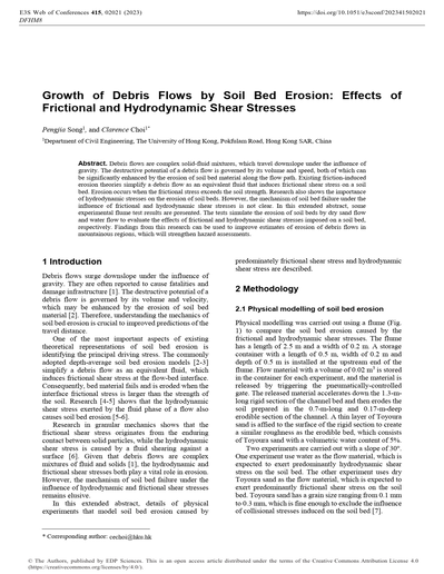
Growth of Debris Flows by Soil Bed Erosion: Effects of Frictional and Hydrodynamic Shear Stresses
Debris flows are complex solid-fluid mixtures, which travel downslope under the influence of gravity. The destructive potential of a debris flow is governed by its volume and speed, both of which can be significantly enhanced by the erosion of soil bed material along the flow path. Existing friction-induced erosion theories simplify a debris flow as an equivalent fluid that induces frictional shear stress on a soil bed. Erosion occurs when the frictional stress exceeds the soil strength. Research also shows the importance of hydrodynamic stresses on the erosion of soil beds. However, the mechanism of soil bed failure under the influence of frictional and hydrodynamic shear stresses is not clear. In this extended abstract, some experimental flume test results are presented. The tests simulate the erosion of soil beds by dry sand flow and water flow to evaluate the effects of frictional and hydrodynamic shear stresses imposed on a soil bed, respectively. Findings from this research can be used to improve estimates of erosion of debris flows in mountainous regions, which will strengthen hazard assessments.
022
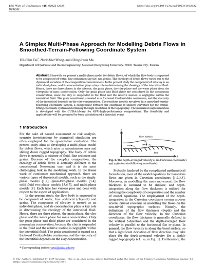
A Simplex Multi-Phase Approach for Modelling Debris Flows in Smoothed-Terrain-Following Coordinate System
Herewith we present a multi-phase model for debris flows, of which the flow body is supposed to be composed of water, fine sediment (clay/silt) and grains. The rheology of debris flows varies due to the dynamical variation of the composition concentrations. In the present study the component of silt/clay is an individual phase, and its concentration plays a key role in determining the rheology of the interstitial fluid. Hence, there are three phases in the mixture, the grain phase, the clay phase and the water phase from the viewpoint of mass conservation. Only the grain phase and fluid phase are considered in the momentum conservation, since the clay is suspended in the fluid and the relative motion is negligible within the interstitial fluid. The grain constituent is treated as a frictional Coulomb-like continuum, and the viscosity of the interstitial depends on the clay concentration. The resultant models are given in a smoothed-terrain-following coordinate system, a compromise between the constraint of shallow curvature for the terrain-fitting coordinate system and retaining the high resolution of the topography. The numerical implementation is developed with the CUDA-library for GPU-high-performance computations. The feasibility and applicability will be presented by back calculation of a historical event.
023
Experiments on and numerical calculations of debris flows passing through narrowed and widened channel regions
We clarified the dynamics of debris flows in areas wherein the topography changes abruptly. First, the dynamics of debris flow through a constriction were investigated by experimentally generating non-uniform flow conditions. Then, numerical calculations were performed using an erosion/deposition rate equation that considers the pressure gradient in a constriction, and compared with the experimental data.
024
Experiments on and numerical calculations of debris flows passing through narrowed and widened channel regions
We clarified the dynamics of debris flows in areas wherein the topography changes abruptly. First, the dynamics of debris flow through a constriction were investigated by experimentally generating non-uniform flow conditions. Then, numerical calculations were performed using an erosion/deposition rate equation that considers the pressure gradient in a constriction, and compared with the experimental data.
025
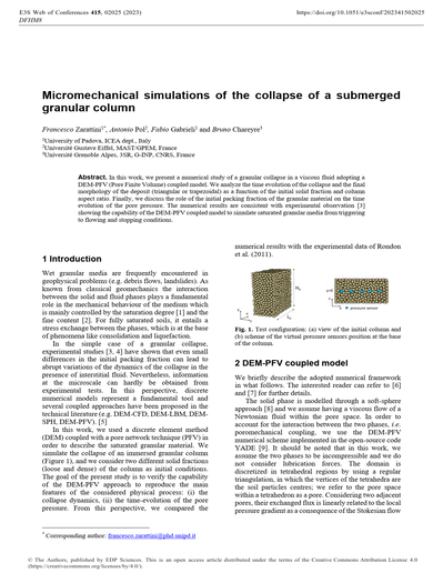
Micromechanical simulations of the collapse of a submerged granular column
In this work, we present a numerical study of a granular collapse in a viscous fluid adopting a DEM-PFV (Pore Finite Volume) coupled model. We analyze the time evolution of the collapse and the final morphology of the deposit (triangular or trapezoidal) as a function of the initial solid fraction and column aspect ratio. Finally, we discuss the role of the initial packing fraction of the granular material on the time evolution of the pore pressure. The numerical results are consistent with experimental observation [3] showing the capability of the DEM-PFV coupled model to simulate saturated granular media from triggering to flowing and stopping conditions.
026
Mixture theory-based SPH model for submerged landslide
A novel SPH model aimed at solving the coupled water-soil problems is proposed based on the mixture theory. This method is featured with the spatially overlapped dual continua for both fluid and solid phases. The water phase is modeled as a weakly-compressible Newtonian fluid, and the soil phase is modeled using an elastoplastic constitutive model. The benchmark problem, fully submerged soil subjected to gravity, is examined to validate this SPH model. Finally, a submerged landslide is simulated to demonstrate the capability of the proposed SPH model in solving the dynamic soil–water coupling problems.
Monitoring, Detection and Warning
001
A new real-time debris flow and avalanches detection system based on optical fiber sensing
The real-time detection of potentially destructive water, earth and snow mixtures such as debris flow and avalanches is a topic of growing interest to mitigate the risk in anthropized areas such as the Alpine region. In view of this, a new cutting-edge debris flow and avalanche detection system, called OPTIALP, was developed. The proposed system exploits the polarization variations induced on the fiber by mechanical vibrations, for the automatic detection along their propagation path of potentially destructive snow and soil-water mixtures. One of the main values-add of the OPTIALP system is the “quasi distributed” and spatially continuous detection along the whole fiber which improves the current monitoring technologies relying on “discrete” monitoring points and sensors. The OPTIALP system was designed and thoroughly tested in the laboratory environment by means of a specific setup. Over 650 tests were carried out and a new signal processing algorithm developed in Matlab environment capable to interpret the data acquired was created. The results showed that the OPTIALP system is able to correctly identify the signals produced by lab-scale mass movements.
002
Performance of the debris flow alarm system ALMOND-F on the Rochefort Torrent (Val d’Aosta) on August 5, 2022
On August 5, 2022 in the Rochefort torrent (Val Ferret, Mont Blanc), a debris flow occurred that invaded the road connecting the valley with the village of Courmayeur. The debris flow interrupted the car traffic and damaged the bridge that crosses the torrent and the aqueduct that serves the municipality of Courmayeur. Due to the recurrence of similar events, in 2017 the Valle d’Aosta Region had decided to install a monitoring and warning system for debris flows, close to the bridge on the Rochefort torrent, to interrupt the traffic in both directions through a pair of traffic lights in case of debris flow. The system, named ALMOND-F (ALarm and MONitoring system for Debris-Flow), has been installed along the torrent, few tens of meters upstream of the bridge. ALMOND-F adopts a warning algorithm that is based on the variation of the seismic signal intensity produced by debris flows and that had been thoroughly tested in previous years in the instrumented area of the Gadria basin. On August 5, 2022 the warning system activated the traffic lights and stopped the traffic about three minutes before the debris flow invaded the road. It is the first time that the ALMOND-F system is utilized in a real risk situation to protect the population, after some years of controlled tests carried out in an instrumented area. Even though this represents an undoubted technological success, the installation of ALMOND-F requires several issues to be addressed to grant the highest level of safety. For instance, the presence of other active debris-flow channels and/or natural risks in the same valley may represent a limitation to the installation of a site-specific alarm system. The installation of the Rochefort torrent, opportunely optimized also on the basis of the feedbacks of the August 5, 2022 debris flow event, could become a useful case study and so provide indications and suggestions on the mitigation of the debris flow risk through the use of warning systems.
003
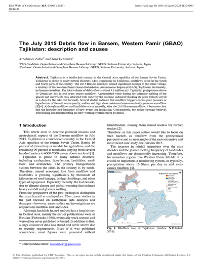
The July 2015 Debris flow in Barsem, Western Pamir (GBAO) Tajikistan: Description and causes
Tajikistan is a landlocked country in the Central Asia republics of the former Soviet Union. Tajikistan is prone to many natural disasters. Most commonly in Tajikistan, mudflows occur in the South and North parts of the country. The 2015 Barsem mudflow caused significant damage to the entire village, a territory of the Western Pamir Gorno-Badakhshan Autonomous Region (GBAO), Tajikistan; fortunately, no human casualties. The total volume of debris flow is about 4.9 million m3. Typically, precipitation above 15-20mm per day in arid areas causes mudflow. Accumulated water during the intensive melting of the glacier and snowfields was saturated with water by the moraine sediment blocking its paths (which served as a dam for the lake that formed). Several studies indicate that mudflow triggers excess pore pressure or liquefaction of the soil; consequently, sudden and high shear resistance losses eventually generate a mudflow [5][6]. Although mudflows and landslides occur annually, after the 2015 Barsem mudflow, it becomes clear that the intensity and frequency of new events are increasing. Consequently, the author strongly believes establishing and implementing an early warning system can be essential.
004
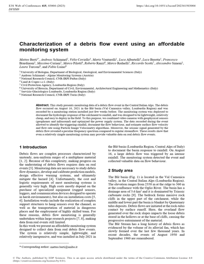
Characterization of a debris flow event using an affordable monitoring system
This study presents monitoring data of a debris flow event in the Central Italian Alps. The debris flow occurred on August 16, 2021 in the Blè basin (Val Camonica valley, Lombardia Region) and was recorded by a monitoring station installed just few weeks before. The monitoring system was deployed to document the hydrologic response of the catchment to rainfall, and was designed to be lightweight, relatively cheap, and easy to deploy in the field. To this purpose, we combined video cameras with geophysical sensors (geophones and infrasound) and optimized the power supply system. The data recorded during the event allowed to identify the triggering rainfall, document the flow behaviour, and estimate surface flow velocity and flow rate using Particle Image Velocimetry algorithms. Moreover, the seismic signal generated by the debris flow revealed a peculiar frequency spectrum compared to regular streamflow. These results show that even a relatively simple monitoring system may provide valuable data on real debris flow events.
005
A model-based early warning system for runoff-generated debris-flow occurrence: Preliminary results
Early warning systems for debris flows are low cost measures for mitigating this kind of hazard. The early warning systems provide a timely alert for upcoming events in order to take protective measures, such as closing railways-roads, evacuating people from the threatened areas, and put rescue forces into readiness. These systems usually are sensor-based, and the alert time is the interval between the timing of the first detachment of debris flow by a sensor and its arrival into the threatened area. At the purpose of increasing the alert time, we propose an early warning system based on a model-cascade: nowcasting, hydrological- and triggering models. Nowcasting anticipates rainfall pattern that is transformed into runoff by the hydrological model. The triggering model estimates the volume of sediments that the runoff can entrain, and compares it with a critical threshold. If this is exceeded the alert is launched. The proposed early warning system is tested against the available data of the Rovina di Cancia (Northeast Italy) site.
006
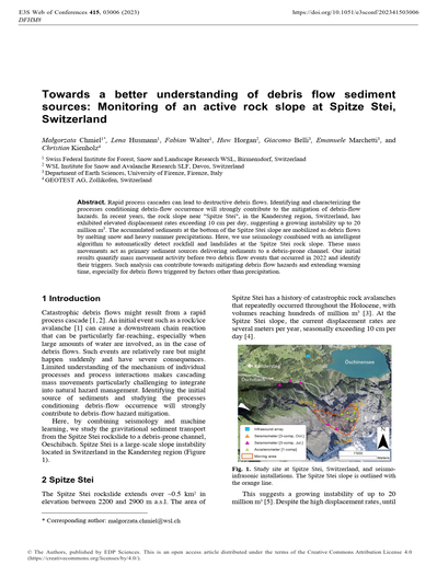
Towards a better understanding of debris flow sediment sources: Monitoring of an active rock slope at Spitze Stei, Switzerland
Rapid process cascades can lead to destructive debris flows. Identifying and characterizing the processes conditioning debris-flow occurrence will strongly contribute to the mitigation of debris-flow hazards. In recent years, the rock slope near “Spitze Stei”, in the Kandersteg region, Switzerland, has exhibited elevated displacement rates exceeding 10 cm per day, suggesting a growing instability up to 20 million m3. The accumulated sediments at the bottom of the Spitze Stei slope are mobilized as debris flows by melting snow and heavy summer precipitations. Here, we use seismology combined with an intelligent algorithm to automatically detect rockfall and landslides at the Spitze Stei rock slope. These mass movements act as primary sediment sources delivering sediments to a debris-prone channel. Our initial results quantify mass movement activity before two debris flow events that occurred in 2022 and identify their triggers. Such analysis can contribute towards mitigating debris flow hazards and extending warning time, especially for debris flows triggered by factors other than precipitation.
007
Keynote lecture. Debris-flow detection for early warning purposes: Recent advances, open problems, and future challenges
The mitigation of risk caused by debris flows is increasingly pursued by means of non-structural measures, including early warning systems (EWSs). Nowadays, EWSs are becoming attractive thanks to their flexibility and due to the new paradigm of smart sensor networks, proposed as a tool to monitor and gather intelligence from the surrounding environment. Also, an increasing number of extreme meteorological events is expected due to climatic changes, resulting in a consequent growing risk in areas considered safe so far. Although the technological development of detection systems based on low-cost sensor networks has recently spurred a great deal of interest, very few success stories exist of EWSs operational for long periods and trusted by local authorities. In this work, I present an overview on the recent advances, open problems, and future challenges in the field of detection of debris flows for early warning purposes, with a special attention to the European Alps. I discuss (i) the uncertainties related to the use of rainfall thresholds and their possible improvement based on field observations in the source areas, (ii) the new opportunities that seismo-acoustic sensors open in terms of warning performances and lead time, (iii) the problematic interaction of EWSs with structural mitigation measures, and (iv) the old but still actual problem of responsibility in issuing an alarm. Finally, I debate the “information paradox” that can contribute limiting the adoption of EWSs in future and the possible benefits of communication and dissemination.
008
When instrument location makes the difference on rainfall thresholds definition: Lessons learned at Cancia, Dolomites
Since debris flows represent one of the most dangerous natural hazard in mountain areas, Early Warning Systems (EWSs) play a crucial role in reducing the risk of these hazardous processes. Robust event pre-alert usually relies on long time series of local rainfall measures. Oftentimes regional rain gauge networks present an insufficient spatial density to grasp the highly variable spatio-temporal dynamics of debris-flow triggering events and thus relying on such networks for developing rainfall thresholds might lead to relatively low rainfall estimates. The present paper reports the development of operational rainfall thresholds for the Cancia EWS, Dolomites (NE Italy). The instrumentation configuration led to the derivation and implementation of a set of rainfall thresholds that significantly enhanced pre-alarm reliability thanks to an optimal spatial distribution of multiple rain gauges within the catchment. Notwithstanding the small number of debris flows occurred during the calibration period, rainfall thresholds were derived considering the whole population of rainfall events showcasing the statistical properties of those events that led to debris-flow initiation. Finally, the validation period served as proof of work for the proposed thresholds with no raised false alarms and with the identification of few minor, but correctly detected, debris flows.
009
What does landslide triggering rainfall mean?
Landslide-triggering rainfall thresholds are often subject to both false negatives (landslides where none are expected) and false positives (no landslides despite thresholds being exceeded). Debris flows and shallow landslides impact communities and infrastructures worldwide. Refinement of the relation between rainfall intensity and landslide occurrence would help remove the imprecise nature of this tool moving forward. Continuous 6-hour gridded precipitation data from over a five-year interval 900 km2, combined with a complete, time-constrained, landslide data base over the same period, are used to derive relations for the probability of shallow landslides with rainfall intensity measured over 6-hour, 12-hour, or 24-hour durations. Previously published and widely used thresholds are quantified in terms of landslide probability per unit area and demonstrate, for different sized study areas, the likelihood that at least one landslide will be initiated at different intensities and durations. Probabilistic distribution of landslides for a given study area and rainfall intensity can be easily derived using the binomial method from these relations.
010
Keynote lecture. Landslide Early Warning Systems: Resources or Problems?
Recent estimates suggest that landslides occur in about 17.1% of the landmasses, that about 8.2% of the global population live in landslide prone areas, and that population exposure to landslides is expected to increase. It is threfore not surprising that landslide early warning is gaining attention in the scientific and the technical literature, and among decision makers. Thanks to important scientific and technological advancements, landslide prediction and early warning are now possible, and landslide early warning systems (LEWSs) are becoming valuable resources for risk mitigation. A review of geographical LEWSs examined 26 regional, national and global systems in the 44.5-year period from January 1977 to June 2019. The study relevaled that only five nations, 13 regions, and four metropolitan areas benefited from operational LEWSs, and that large areas where landslide risk to the population is high lack LEWS coverage. The review also revealed that the rate of LEWSs deployment has increased in the recent years, but remains low, and that reniewed efforts are needed to accelerate the deployment of LEWSs. Building on the review, recommendations for the further development and improvement of geographical LEWSs are proposed. The recommendations cover six areas, including design, deployment, and operation of LEWS; collection and analysis of landslide and rainfall data used to design, operate, and validate LEWSs; landslide forecast models and advisories used in LEWSs; LEWSs evaluation and performance assessment; operation and management; and communication and dissemination. LEWSs are complex and multi-faceted systems that require care in their design, implementation and operation. To avoid failures that can lead to loss of credibility and liability consequences, it is critical that the community of scientists and professionals who design, implement and operate LEWSs takes all necessary precautions, guided by rigorous scientific practices.
011
Monitoring and modelling of debris-flow erosion in the Rebaixader catchment (Pyrenees, Spain)
Debris flow and other torrential processes can entrain large volumes of sediments along their runout path. Since the debris-flow hazard strongly depends on the volume, the research on the entrainment is relevant and has been analysed by multiple approaches in the past. In this study, the erosion volume due to torrential processes has been monitored in the Rebaixader catchment (Spain) by digital elevation models obtained from Uncrewed Aerial Vehicle (UAV) surveys and by the instrumental monitoring system installed in the channel reach. In addition, the entrainment of debris flows has been modelled by the numerical code FLATModel. The results of both approaches show that debris flows in the studied catchment are characterised by a large entrainment and the assumption of landslide-triggered debris flows has been refuted. Important erosion in the gullies of the initiation area has been detected by the UAV data and the numerical modelling. An average annual erosion volume of about 6100 m3/y has been determined.
012
Study of debris flow peak discharge at Kamikamihorizawa Creek
Prediction of the peak discharge of debris flow is one of the most important factors in mitigating debris flow disasters. Currently, empirical methods based on the relationship between the peak discharge and total debris flow volume (magnitude) for many debris flow events are used to estimate peak discharge for planning or designing debris flow countermeasures in Japan. In order to estimate the peak discharge of debris flow with high accuracy, the debris flow monitoring sensors with load cell and pressure sensor (hereafter referred to as a DFLP system), was installed to evaluate various characteristics during floods involving debris flows at Kamikamihorizawa Creek. During the debris flow that occurred on August 29, 2019 at Kamikamihorizawa Creek, seven surges corresponding to debris flow events were monitored by the DFLP system for a 20-minute period. Based on the relationship between the peak discharge and magnitude, the observation data of Kamikamihorizawa Creek, Illgraben and Schipfenbach has been added to previous data from the literature and the relationship has been updated. The peak discharge and magnitude of debris flow on August 29, 2019 at Kamikamihorizawa Creek exhibited distributions similar to past observation data, which shows that the relationship between peak discharge and magnitude follows a similar trend.
013
Initiation and runout characteristics of partially saturated debris flows in Ohya landslide scar, Japan
A partially saturated flow, which has an unsaturated layer in its upper part, has been monitored in the steep initiation zones of debris flows. Understanding the initiation and runout characteristics of partially saturated flows is essential for predicting the timing and magnitude of downstream debris flows. Monitoring performed using time-lapse cameras and water pressure sensors in the Ohya landslide scar in central Japan allowed us to obtain data on a series of partially saturated debris flow surges from initiation to termination on July 6, 2020, and July 13, 2021. Debris flow surges were mainly induced by repetitive mass movement of sediment deposit caused by the overland flow erosion of channel deposits, channel deposit slides, and water and sediment supply from channel banks and tributaries. The excess pore water pressure in a partially saturated flow on July 6, 2020, was clearly higher than that on July 13, 2021. Rainfall patterns, which control the water content in channel deposits, and the flow height likely affect the magnitude of the excess pore water pressure in partially saturated flows.
014
Study of debris-flow initiation through the analysis of seismic signals
Monitoring data gathered in the headwaters of the Gadria catchment, eastern Italian Alps, have been analysed to study debris-flow initiation. The active channel, located at 2200 m a.s.l., was instrumented with a geophone, a time-lapse video camera and a rain gauge. The peak amplitude and duration of the seismic signals and their frequency content were analysed and compared with video images. Results showed that different seismic sources produced signals with different characteristics and that it is possible to discriminate the most intense runoff by analysing the combination of peak amplitude and duration of the seismic signal. The further development of this research would be to create an algorithm able to automatically classify the seismic sources and identify intense channel processes that can generate debris flows. In perspective, the combination of seismic detection in the initiation area with monitoring just above the infrastructures at risk could represent an effective solution to expand the lead time of an early warning system.
015
Continuous debris flow monitoring using DFLP and LVP on Sakura-jima Island
Since 2010, numerous debris flows have occurred on Sakura-jima Island due to rainfall events that occurred after extensive ash deposition associated with volcanic activity. The study area included the Nojiri and Arimura rivers in the southwestern and southeastern parts of Sakura-jima, respectively. Debris flow monitoring systems consisting of loadcell and pressure sensor (DFLP) were installed to evaluate characteristics of moving weight and so on during debris flows. The systems were installed at the Arimura River No. 3 sabo dam in June in 2012 and at the Nojiri River No. 1 sabo dam in 2014. In addition, LVP (Load, Vibration and Pressure) sensors consisting of loadcells and accelerometers for measuring vibration and pressure were installed on the riverbed for debris flow detection. Modified LVP systems were installed at the Nojiri River No. 7 sabo dam in February in 2015, and at the Arimura River No. 3 sabo dam in October in 2016. Interesting characteristics of debris flows were obtained by the DFLP and LVP systems. The findings showed that the sediment concentrations of both the coarse and the suspended and liquid phases could be estimated by the DFLP systems, and several patterns of debris flows were observed by the LVP systems.
016
Volume, Peak discharges and Froude Number of Debris-Flow Surges: 10 Years of Monitoring on the Réal Torrent (France)
This work presents a summary of data on debris-flow monitoring stations focusing on the surge scale rather than full-scale debris-flow event (several fronts and surges with intermediate diluted flows). Surge-scale debris-flow data are not easily accessible for modellers but would be very beneficial for the community. A summary of the data processing protocol is offered, and its application to the monitoring station of the R?al Torrent is described (drainage area: 2 km2, SE France). Investigated bulk surge features are volume, front height, peak discharge, and Froude number. This investigation leads to statistical distributions of these parameters on 34 surges gathered from 2011 to 2020. Their volumes are typically a few thousand cubic metres, their peak flow height is 1 to 2 m, their peak discharge is a few dozens of cubic metres per second and their Froude number is near critical. Results drawn from this work will be a great asset for modellers to better feed their numerical experiments with realistic, field-driven features.
017
Soil Water Content Regression Analysis of Measurement Data from Hyperspectral Camera in Weathered Granite Soils
Soil water content is one of the most common physical parameters that cause landslides or debris flow. Therefore, it is of very importance to determine or predict the water content quickly and non-destructively. This study investigates the hyperspectral information in the visible near-infrared regions (VNIR) of different samples of granite soils possessing varying water content. Totally 162 granite samples were taken from each mountain area. The samples with different water contents were examined using a hyperspectral radiometer operating in the 400~1000nm range by obtaining the spectral curves. It was found that the variation of VNIR is consistent with the water content variation of weathered granite soils, and the hyperspectral camera was able to detect it. A Partial Least Squares Regression (PLSR) analysis was applied to develop a calibration-model. The PLSR model resulted in a good correlation between the water content and VNIR profile. The results demonstrate that the hyperspectral camera combined with the PLSR model can be a useful and non-destructive tool for determining soil water contents in the weathered granite soils.
018
Monitoring debris flows in the Gadria catchment (eastern Italian Alps): Data and insights acquired from 2018 to 2020
This work analyses seven debris flows recorded between 2018 and 2020 in the Gadria instrumented catchment (South Tirol). We focus on three aspects not previously explored in this catchment: (i) the debris-flow transfer times between the headwaters and the outlet; (ii) the longitudinal variability of debris-flow velocity between the three downstream monitored cross-sections, and (iii) the characteristics of the secondary surges observed in three debris flows. In most cases, the mean velocity of the debris flow estimated from the upper to the lower channel reaches (for travel distance of 2155 m) is rather low, ranging between 1.9 and 3.9 m/s. This result could indicate a progressive slowing down, and possibly even temporary stops of debris flows along the path. Some variability in flow velocity was observed between two channel reaches in the lower part of the catchment (0.7 – 2.3 m/s in the upstream reach, and 1.4 – 4.7 in the downstream one). Regarding the secondary surges, these have been noted to occur superimposed on slow-moving slurry-type phases. The mean velocity of the secondary surges varied between 3.5 and 8.9 m/s, with an average value close to 6 m/s for all three events. Their regular shape, duration, and depth suggest that such surges were generated by flow instabilities, with no external forcing.
019
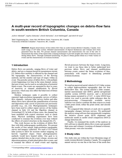
A multi-year record of topographic changes on debris-flow fans in south-western British Columbia, Canada
Repeat observations of four debris-flow fans in south-western British Columbia, Canada, were made using a UAV-lidar system. Detailed measurements of deposit thicknesses and volumes have been generated from the data. We present channel measurements and characteristics for one of the sites to demonstrate the utility of the repeat lidar scanning technique to provide insights into where avulsions occur during debris flows. Through continued monitoring, we plan to obtain greater detail on a wider variety of events and the characteristics of avulsion locations.
020
Long-term monitoring of sediment runoff for an active sediment control in Joganji River
There were huge sediment yielding and deposition due to debris flows by breaking natural landslide dams which were formed by earthquake in 1858 at upstream reach of Joganji River. Sediment transportation is still active by debris flow and flow with bedload due to rainfall, though a lot of erosion control dams have been constructed. Continuously measuring sediment runoff for long term along a main river is necessary to evaluate the propagation of sediment after the huge events for sediment management in the basin using well hydrological information. Appropriate tools are selected and applied to monitoring in the area managed by Tateyama Mountain Area Sabo Office along Joganji River, using a Reid-type bedload slot sampler, robust-type hydrophone and velocity meter on the bed for bedload and turbidity meter for washload. Monitored data is concentratedly collected at the office to apply risk management for sediment movement due to heavy rainfall and so on. Several typical data and problems to solved were shown because it passed around twenty years since sediment monitoring started, and those are reported in present study.
021
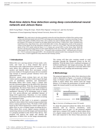
Real-time debris flow detection using deep convolutional neural network and Jetson Nano
This study aims to develop a potential system for real-time detection of debris flow motion using a deep convolutional neural network (CNN) and image processing techniques. A system consisting of a pre-trained CNN model, NVIDIA Jetson Nano, and a camera was used to identify debris flow movement. The pre-trained CNN model was trained on an image dataset derived from 12 debris flow videos obtained from small flume tests, large flume tests, and several debris flow events. The application results of the proposed system on the flume test in the laboratory reached an F1 score of 72.6 to 100%. The real-time processing speed of the CNN model achieved from 2 to 21 frames per second (FPS) on the Jetson Nano. Both the accuracy and the processing speed of CNN model depend on the size of the video input and the input size of the model CNN. The CNN model of 320 × 320 pixels with a resolution of 800 × 480 pixels gives accuracy (F1 = 99.2%) and processing speed (FPS = 20) considered the optimal model when running the Jetson Nano device; thus, it can be applied for early detection and warning systems.
022
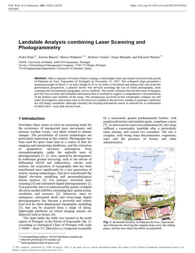
Landslide Analysis combining Laser Scanning and Photogrammetry
After a sequence of weeks of heavy raining, a catastrophic mass movement occurred in the parish of Palmeira de Faro, Esposende (N Portugal) on November 23, 2022. The collapsed slope presented a maximum height of about 21 m and a length of 45 m. In order to document and analyse this case from the geotechnical perspective, a general survey was devised including the use of aerial photography, laser scanning and conventional topographic survey methods. The results obtained showed that these techniques provide very accurate and abundant information that is essential to support a comprehensive documentation of the features and variables of the slope. The mechanisms involved in this catastrophic collapse are still under investigation, and causes such as the excessive rainfall in the previous months or geologic conditions are still being considered, although currently the existing information seems to indicate for a combination of debris flow / rock slide driven event.
023
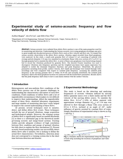
Experimental study of seismo-acoustic frequency and flow velocity of debris flow
Seismo-acoustic wave radiated from debris flows motion is one of the main properties used for its monitoring and detection. Understanding the Seismo-acoustic wave using geophone recordings may give us great insight into the physical process of debris flows such as flow velocity and flow rate. To connect the seismo acoustic observation to the debris flows motion, vibration signal recorded from fixed geophones were analysed. In this study, a small-scale granular flow of volume 0.2 m3 consisting of material with average particle diameter 3.34 mm was simulated in a hydraulic flume with cross section of 0.5 m X 0.5 m through granular bed to simulate the debris flow. A series of three-axis geophones were buried along channel bed to record the vibrations produced by granular flows. The discrete Fourier transform was used to decompose vibrations into frequency spectrum and the weighted non-linear least square regression was adopted to isolate the dominant frequency functions and peak frequency. Meanwhile, the physical parameters including front profile, surface velocity, flow depth and discharge were tracked through video recordings and were compared with respect to isolated peak frequency. Assuming the radiated peak frequency in the moving granular flow is within 20-50 Hz and normally distributed, the isolated peak frequency shift in the fixed geophone location was analysed with the tracked flow parameters. Results shows that the peak frequency shift seems to have a non-linear relation with the surface velocity.
024
Bedrock Erosion by Debris Flows at Chalk Cliffs, Colorado, USA: Implications for Bedrock Channel Evolution
Debris flow erosion into bedrock helps to set the pace of mountain denudation, but there are few empirical observations of this process. We studied the effects of debris flows on bedrock erosion using Structure-From-Motion photogrammetry and multiple real-time monitoring measurements. We found that the distribution of bedrock erosion across the channel cross-section could be generalized as an exponentially decreasing function of height above the channel thalweg. Using this empirical function, we simulated the erosion at a cross-section after the theoretical passage of a migrating knickpoint effectively matching the upstream pre-knickpoint cross-sectional shape to the downstream post-knickpoint cross-sectional shape via debris-flow bedrock erosion.
025
MAMODIS – A low-cost monitoring system for debris flows based on infrasound and seismic signals
The automatic detection of sediment related disasters like landslides, debris flows and debris floods, gets increasing importance for hazard mitigation and early warning. Past studies showed that such processes induce characteristic seismic signals and acoustic signals in the infrasonic spectrum which can be used for event detection. The presented system MAMODIS (MAss MOvement Detection and Identification System) is a detection system for debris flows, debris floods and avalanches based on a combination of infrasound and seismic signals. The detection system consists of one infrasound sensor, one geophone and a microcontroller, where a specially designed detection algorithm is executed. This algorithm reliably detects events in real time directly at the sensor site. The setup can be easily installed beside a torrent or an avalanche path and therefore can be used as a low-cost and practicable solution for early warning. In addition, this system offers first information of the process-type and a rough estimation of the peak discharge and the total volume for debris flows and debris floods. These values are calculated from the infrasound and seismic signals. Currently the system is installed on several test sites in Austria, Switzerland and Italy.
026
Photogrammetrically UAV based terrain data generation and automatic extraction of torrential properties
Debris flows are a severe hazard in mountainous regions. However, cost-effective long-term studies of debris flows are seldom, which leads to substantial uncertainties in hazard mitigation methods. This paper investigates whether cost-effective remote sensing techniques can be applied to assess the hazards of mountain torrents and to gather accurate long-term information on the development of the watershed. Torrents that are prone to debris flows are often devoid of vegetation and can thus be well surveyed using photogrammetric methods based on uncrewed aerial vehicle (UAV) surveys. The possibility of extracting automatically torrent parameters from high-resolution terrain models, such as cross-sectional area or slope, is explored. The presented methodology yields continuous and automatically derived parameters along the torrent, which is a major advantage over pointwise field surveys. Cross-validation with field measurements reveals a strong agreement. These parameters are very accurate along highly incised sections, while they are severely limited along sections with steep adjacent hillslopes and/or dense vegetation. We show that these kinds of assessments greatly gain from UAV data followed by automatic parameter extraction. The extracted parameters provide insights so that key sections and weak points can be identified and accurately assessed in the field. We find that UAV data can contribute to a comprehensive, reproducible and objective assessment of torrent processes and predispositions. However, ground-based fieldwork is still essential and further research on remote sensing-based hazard assessment of torrents prone to debris flows is crucial.
027
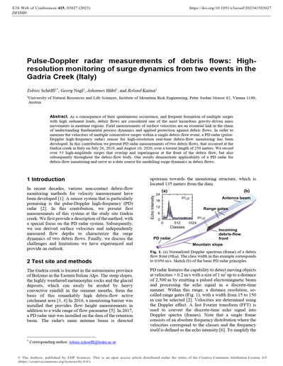
Pulse-Doppler radar measurements of debris flows: High-resolution monitoring of surge dynamics from two events in the Gadria Creek (Italy)
As a consequence of their spontaneous occurrence, and frequent formation of multiple surges with high sediment loads, debris flows are considered one of the most hazardous gravity-driven mass movements in montane regions. Field measurements of surface velocities are an essential link in the chain of understanding fundamental process dynamics and applied protection against debris flows. In order to measure the velocities of multiple consecutive surges within a single debris-flow event, a PD radar (pulse-Doppler high-frequency radar) sensor for high-resolution real-time debris-flow monitoring has been developed. In this contribution we present PD radar measurements of two debris flows, that occurred at the Gadria creek in Italy on July 26, 2019, and August 10, 2020, over a torrent length of 250 meters. We record over 55 high-amplitude surges that overlap and superimpose at the front of the debris flow, but also subsequently throughout the debris-flow body. Our results demonstrate applicability of a PD radar for debris-flow monitoring and serve as a data source for modelling surge dynamics in debris flows.
028
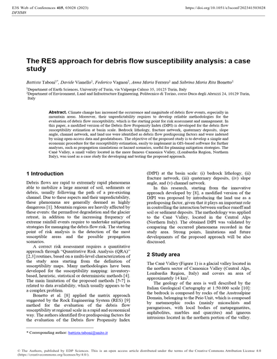
The RES approach for debris flow susceptibility analysis: A case study
Climate change has increased the occurrence and magnitude of debris flow events, especially in mountain areas. Moreover, their unpredictability requires to develop reliable methodologies for the evaluation of debris flow susceptibility, which is the starting point for risk assessment and management. In this paper, a modified version of the Debris flow Propensity Index (DfPI) is developed for the debris flow susceptibility estimation at basin scale. Bedrock lithology, fracture network, quaternary deposits, slope angle, channel network, and land use were identified as debris flow predisposing factors and were indexed by using open-access data and geodatabases. The objective of the proposed study is to develop a simple and economic procedure for the susceptibility estimation, easily to implement in GIS-based software for further analyses, such as propagation simulations or hazard scenarios, useful for planning mitigation strategies. The Can? Valley, a small valley located in the more famous Camonica Valley, (Lombardia Region, Northern Italy), was used as a case study for developing and testing the proposed approach.
029
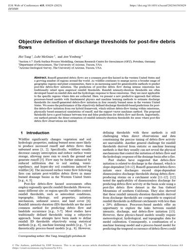
Objective definition of discharge thresholds for post-fire debris flows
Runoff-generated debris flows are a common post-fire hazard in the western United States and a growing number of regions around the world. As wildfire continues to emerge across a broader range of geographic regions and plant communities, there is an increasing need for generalizable methods to predict post-fire debris-flow initiation. The prediction of post-fire debris flow during intense rainstorms has traditionally relied upon empirical rainfall thresholds. Rainfall intensity-duration thresholds are often developed based on rainfall data and the hydrologic response to those rainstorms. They are most applicable to the specific regions where data are collected. Here, we present a new predictive approach that utilises processes-based models with fundamental physics and machine learning methods to estimate discharge thresholds for runoff-generated debris-flow initiation in four recently burned areas in the western United States. We assess the performance of the objectively defined discharge threshold-based predictions for post-fire debris-flow initiation from our hybrid framework, which utilises debris-flow timing within rainstorms, physically based numerical simulations of runoff, and the support vector machines method. The proposed thresholds have a good balance between true and false predictions for debris flow and floods. Importantly, our method permits the direct estimation of rainfall intensity-duration thresholds for areas where post-fire debris flow observations are limited.
030
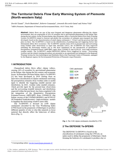
The Territorial Debris Flow Early Warning System of Piemonte (North-western Italy)
Debris flows are one of the most frequent and dangerous phenomena affecting the Alpine environment; they are responsible of 36% of casualties due to gravitational phenomena in the Italian Alps during the last century. In the Western Italian Alps (Piemonte, Italy) a Territorial Debris Flow Early Warning System (Te-DFEWS) aimed to forecast and predict the occurrence of sediment mass-transport has been developed, based on the characterization of small Alpine catchments (< 50 km2) and the processes that take place in these. The Te-DFWES is based on the identification of predisposing and triggering factors that determinate debris flow occurrence. The Te-DFEWS operates from 2010 in present-time and nowcasting using weather radar observations as input data. Recently (2021), the Te-DFEWS has been improved extending the forecasting window (up to 48h from simulation) by the introduction of Quantitative Precipitation Estimate/Forecast (QPE/QPF) input from COSMO-2I and ICON-IT, local high-resolution weather models. The Te-DFEWS, named DEFENSE (DEbris Flows triggEred by storms – Nowcasting SystEm) and the related warning procedures are presented as an operational tool integrated in the Regional Warning System for Geo-hydrological and Hydraulic Risk at the Functional Centre of Piemonte, managed by the Regional Agency for Environmental Protection of Piemonte (Arpa Piemonte).
031
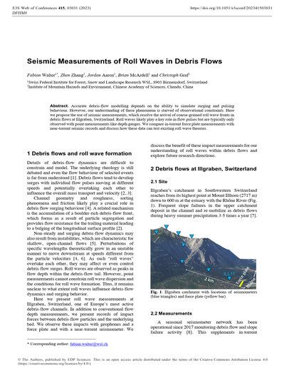
Seismic Measurements of Roll Waves in Debris Flows
Accurate debris-flow modelling depends on the ability to simulate surging and pulsing behaviour. However, our understanding of these phenomena is starved of observational constraints. Here we propose the use of seismic measurements, which resolve the arrival of coarse-grained roll wave fronts in debris flows at Illgraben, Switzerland. Roll waves likely play a key role in flow pulses but are typically only observed with point measurements like depth gauges. We compare in-torrent force plate measurements with near-torrent seismic records and discuss how these data can test existing roll wave theories.
032
Debris flow seismo-acoustic wave in a finite layer waveguide
The seismo-acoustic wave detection is a popular method to detect debris flows. It has been successfully used in different early warning systems worldwide. However, more information is embedded in the signals related to flow conditions. This research uses theoretical derivation to connect signals with debris flow propagation speed. We assume debris flow generates seismo-acoustic stress acting on a river bed and the seismo-acoustic waves propagate in a finite layer waveguide below the channel. Then, the propagation of seismo-acoustic stress was solved with the elastic wave equations along the channel. For any fixed point in this waveguide, the frequency of the recording signal can be translated as a function of debris flow propagation speed and seismo-acoustic wave velocity. The result shows that there is a Doppler-like property for a recorded signal where debris flow propagation speed can cause a frequency shift. This result also indicates that different superior frequency bands would be recorded from different media.
033
Detection of debris-flow events from seismic signals using Benford’s law
The first step in building an early warning system using seismic signals is to automatically identify events of interest. Here, the first digit distribution of seismic signals generated by debris flows and other surface processes was calculated to validate compliance with Benford’s law (BL). A detector model for debris flow events was introduced based on amplitude range and goodness of fit of BL. We show that seismic signals generated by debris flows, landslides, and bedload transport follow the BL. These events release more energy and last longer than rockfalls, which do not follow BL. In the test dataset with 1224 samples, the accuracy of the detector model in identifying debris flow events was 0.75.
Role of Disturbance
001
Debris-flow activity and sediment dynamics in the landslide-influenced Lattenbach catchment, Austria
Deep seated landslides are common phenomena in Alpine areas. In case of a direct connectivity with the channel system, the catchment’s sediment yield and the probability of other forms of mass wasting processes such as debris flows may be increased significantly. Up to now, sediment dynamics related to deep-seated landslides and debris flows have not been quantified. The Lattenbach catchment (basin area 5,3 km², relief 2134 m) in Grins (Tyrol, Austria), is an example for an active DF-site, where there is geomorphological evidence of deep-seated landslide activity. In this study we shed light (1) on the location and size of active landslides in the catchment, that may deliver sediment to the channel system. Furthermore, we want to (2) quantify the contributed sediment volumes by these landslides (3) and estimate the exported sediment by debris flow. We apply an image correlation algorithm to high resolution ALS and TLS terrain models of derived over a period of 14 years to calculate surface movement rates within the catchment and locate deep seated landslide activity. We further assess the sediment yield of these landslides to the channel system and relate that with DF-volumes measured by a monitoring station at the catchment outlet. We find that there are five deep-seated landslide bodies directly connected to the channel system in the catchment. These are the largest source of sediment and significantly increases the overall sediment yield of the catchment. Our study shall contribute to the limited knowledge about the importance of deep-seated landslides for sediment dynamics and debris-flow activity, as their presence is predicted to be more frequent in the wake of global warming.
002
Keynote lecture. Forecasting the inundation of postfire debris flows
In the semi-arid regions of the western United States, postfire debris flows are typically runoff generated. The U.S. Geological Survey has been studying the mechanisms of postfire debris-flow initiation for multiple decades to generate operational models for forecasting the timing, location, and magnitude of postfire debris flows. Here we discuss challenges and progress for extending operational capabilities to include modeling postfire debris-flow inundation extent. Analysis of volume and impacted area scaling relationships indicated that postfire debris flows do not conform to assumptions of geometric self-similarity. We documented sensitivity of impacted areas to rainfall intensity using a candidate methodology for generating inundation hazard assessments. Our results emphasize the importance of direct measurements of debris-flow volume, inundated area, and high temporal resolution rainfall intensity.
003
The spatial distribution of debris flows in relation to observed rainfall anomalies: Insights from the Dolan Fire, California
A range of hydrologic responses can be observed in steep, recently burned terrain, which makes predicting the spatial distribution of large debris flows challenging. Studies from rainfall-induced landslides in unburned areas show evidence of hydroclimatic tuning of landslide triggering, such that the spatial distribution of events is best predicted by the observed rainfall anomaly relative to climatic norms rather than by absolute rainfall. In this paper, we test whether the spatial distribution of debris flows in response to rainfall can be similarly predicted by rainfall anomaly. The 520 km2 Dolan Fire burn scar in Monterey County, California, USA, spans a sharp hydroclimatic gradient and experienced a widespread storm in January 2021 that triggered floods and debris flows, providing a natural experiment in which to test this hypothesis. In this study, we use remote and field methods to map debris-flow response and examine its spatial heterogeneity. Together with rainfall data, our mapping reveals that the observed anomalies in peak 15-min rainfall intensity (I15) relative to the intensity of the 1-yr return interval storm predict debris-flow occurrence better than the absolute peak I15. Our findings indicate that debris-flow processes and threshold rainfall required for debris-flow initiation may be tuned to local hydroclimate.
004
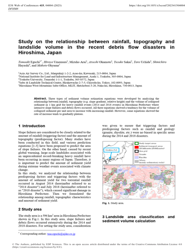
Study on the relationship between rainfall, topography and landslide volume in the recent debris flow disasters in Hiroshima, Japan
Three types of sediment volume estimation equations were developed by analyzing the relationship between rainfall, topography (e.g. slope gradient, relative height) and the volume of collapsed sediment in 1 km grid for heavy rainfall events (2014 and 2018 events) in Hiroshima Prefecture where intensive slope failures and debris flows occurred. All three equations showed a tendency for the volume of collapsed sediment per unit area to increase with increasing rainfall. However, some equations showed the rate of increase tends to gradually plateau.
005
Rainfall-induced shallow landslides triggered after vegetation removed because of fires: G-XSLIP application to Gioiosa Marea (Sicily, Italy)
The paper analyses how vegetation prevents the triggering of rainfall-induced shallow landslides by using the G-XSLIP platform, which is based on G-SLIP model, i.e., the SLIP model updated with vegetation parameters for root reinforcement and rain interception due to canopy. G-XSLIP is applied to an area in Gioiosa Marea (Sicily, Italy), where on 9th September 2016 shallow landslides occurred, depositing on the state road SS 113. The analyses demonstrate that the triggering of these phenomena is related to the removal of vegetation after summer fires some months before, which decreases computed safety factors by about half.
006
Snowmelt-triggered debris flows in seasonal snowpacks
Snowmelt-triggered debris flows commonly occur in mountains. On 14 June 2019, a debris flow occurred on a steep, east-facing slope composed of unconsolidated glacial and periglacial sediments in Yosemite National Park. Originating as a shallow landslide, ~1,300m3 of ripe snow was instantaneously entrained into the debris flow carrying boulders, trees, and soil downslope. The forested area at the toe of the slope strained out debris leaving a muddy slurry to issue across Highway 120 during dewatering. We document this mass movement and assesses its initiation using local snowpack and meteorological data as well as a regional atmospheric reanalysis to examine synoptic conditions. A multiday warming trend and ripening of the snowpack occurred prior to the event as a 500 hPa ridge amplified over western North America leading to record warm 700 hPa temperatures. Anomalous temperatures and cloud cover prevented refreezing of the snowpack and accelerated its ripening with meltwater contributing to soil saturation. Similar conditions occurred during the catastrophic 1983 Slide Mountain debris flow, also hypothesized to be snowmelt initiated. With projected increases in heat waves, our findings can support natural hazard early warning systems in snow-dominated environments.
007
Future global debris flow susceptibility considering climate change, wildfire probability, and glacier retreat
The present-day impact of climate changes on debris flow magnitude, frequency, and susceptibility has been demonstrated in North and South America, Europe, Asia, and New Zealand. Such impacts are expected to increase under future emission scenarios. Future global debris flow susceptibility models provide an international perspective on areas worthy of further, more detailed analyses with regard to geographic changes in global debris flow susceptibility. In this study, future global debris flow susceptibility models are developed under RCP 2.6 and 8.5 IPCC Climate Change Scenarios. These models were further augmented with wildfire probability, and areas of potential glacier retreat, both of which can act as amplifiers to debris flow susceptibility. The results are projected against future urban centers, for a spatial view on potential human vulnerability. Key findings are (1) wildfire acts as a significant amplifier in area and magnitude of debris flow susceptibility in all modeling scenarios, (2) greater than 50% of the studied glaciers reside within higher susceptibility zones when wildfire is not considered, and greater than 75% when wildfire probability is considered, (3) 76 of the studied glaciers are within 5 km of eleven urban centers, (4) 11% of these “urban” glaciers are in higher susceptibility zones when wildfire probability is not considered, and 51% are in higher susceptibility zones when wildfire is considered, (5) about 12% of future urban centers will reside within higher susceptibility zones under both future climate change scenarios. Consideration of these factors, together with traditional environmental factors and triggers, and findings by local and regional glacier-related debris flow researchers, suggests a new paradigm in modeling debris flow susceptibility, at any scale.
008
Debris flow: Simulating the mitigation properties of vegetation
Natural vegetation impacted by debris flows can act as an energy dissipator. This braking effect is similar to the one exerted by baffle arrays. However, this effect, and its potential for hazard mitigation, has been studied only marginally. In this work, we apply a depth-averaged model to reproduce scaled laboratory experiments of flow-forest interaction.
009
Post-wildfire erosion rates and triggering of debris flows: A case study in Susa Valley (Bussoleno)
Post-wildfires geological hazards are an emerging problem in many places, including areas not typically associated with these events such as the Alpine Region. Hazards connected with post-fire processes such as debris-flows and flood-type events threatens people, infrastructures, services and economical activities. Apart from a few examples, there is a lack of models available to quantify the increase in susceptibility as a result of the modification induced by the wildfires. In this work we test the application of a modified version of the RUSLE, on GIS, to quantify the post-fire erosive phenomena for a case study in the north-western Italian Alps. The results of its application, taking advantage of high-resolution rainfall series and data deriving from field surveys, highlight the marked increase (more than 20 times) in erosion rates, quantified by expressing both the EI (erodibility index), the A (monthly soil loss) and the SL (monthly sediment loss) rise. The months of April, May and June represents the larger share of the total quantities. This is a consequence of the noticeable increase of the Erodibility Index EI, which for the post-fire scenario is more than one order of magnitude higher than the pre-fire one.
010
Triggering rainfall intensities for post-wildfire debris flows in the Sonoran Desertscrub plant community
Wildfire makes landscapes more vulnerable to debris flows by reducing soil infiltration capacity and decreasing vegetation cover. The extent to which fire affects debris-flow processes depends on the severity of the fire, the climatology of intense rainfall, the pre-fire plant community, and sediment supply, among other factors. As fire expands into new plant communities and geographic regions, there is a corresponding need to expand efforts to document fire-induced changes and their impacts on debris-flow processes. In recent years, several large wildfires have impacted portions of the Sonoran Desertscrub plant community in Arizona, USA, a plant community where fire has been historically infrequent. Following two of these fires, we monitored debris-flow activity at the watershed scale and quantified wildfire-driven changes in soil hydraulic properties using in-situ measurements with mini disk tension infiltrometers. Results indicate that rainfall intensity-duration thresholds for the initiation of post-fire debris flows in recently burned watersheds within the Sonoran Desertscrub plant community are substantially greater than those in nearby areas dominated by other plant communities, such as chaparral. Results provide insight into the impact of fire on debris-flow processes in a plant community where it is likely to be more impactful in the future and help expand existing post-fire debris flow databases into a plant community where there is a paucity of observations.
011
Rheology of hail-debris flow and implications in flow mobility
During 29-31 January 2021 (austral summer), an extreme storm event triggered catastrophic debris flows in central Chile (33-36°S). At small and precarious rural settlements in the commune of Malloa in central Chile, debris flows where triggered by a hailstorm. Hail-debris flows, with hail volume concentration near 10%-20%, caused 200 injured individuals and 73 damaged houses. In this study, hail-debris flows where modelled using the FLO2D. software, calibrated against flow velocities and flooded areas obtained from audio-visual records taken by local inhabitants (using cell phones) and a high-accuracy post-event topography obtained with a drone. Results suggest that hail content significantly reduces flow resistance compared to typical debris flows, thus increasing flow velocity, and run out. On the other hand, damage to infrastructure was more related to the materiality of the houses (precarious settlements) than to debris flow severity.
012
Study on debris flow monitoring in Mt. Fuji
The Osawa River, which has its headwaters at the top of Mt. Fuji, has one of the largest failure in Japan, the Osawa Failure, in its uppermost part of the catchment. The Osawa Failure produces more than 100,000m3 of sediment every year by erosion and collapse, which causes debris flows and slash avalanches. Since its opening in 1970, the Fuji Sabo Office has been observing the sediment dynamics of the Osawa River through field surveys, observation equipment and aerial photogrammetry, aerial laser survey, and Japanese pipe hydrophone. In 2021, the largest debris flows since the start of observations in the Osawa River occurred twice in March and August. In the March 21 debris flow, 416,000m3 of sediment flowed down from the Osawa Failure, and 482,000m3 was deposited in the alluvial fan. In the August 18 debris flow, 421,000m3 of sediment was deposited in the alluvial fan. Our observations from CCTV cameras, rain gauges, and other equipment installed in the Osawa River indicate that the rainfall characteristics during the two debris flows were different, and that the conditions for debris flows differed depending on the season.
013
Projected Effects of Climate Change on Post Wildfire Debris-Flow Hazards Applied to the 2017 Thomas Fire, California USA
Climate changes are expected to increase the likelihood, volume, and overall hazard of post-wildfire debris flows, but it is a challenge to estimate specific changes and impacts from these hazards. In this study we use climate change models to modify the parameters in predictive equations to demonstrate changes for the 2017 Thomas Fire in California USA if a similar event were to occur in the years 2050 or 2075. Our results show that, based on changes in fire size, the number of burned drainage basins in 2050 would increase by 105% and by 2075 they would increase by 147%. Based on changes in fire size and rainfall effects, the overall volume of debris produced by debris flows would increase by 96% in 2050 and 147% in 2075. Finally, there would be a notable shift in hazard level towards basins classified as high hazard. The hazard models for the 2017 fire classified 54% of the drainage basins (937 total) as high hazard, but by 2050 there would be 60% (1869 total) classified as high hazard. By 2075, 67% of basins would be high hazard (2385 total). This represents an increase in high hazard drainage basins of 99% by 2050 and 155% by 2075. The results of this exercise indicate a substantial future increase in area impacted by post wildfire debris flows, the amount of debris produced, and the level of hazard posed.
Case Studies and Hazard Assessments
001
Hydrologic-hydraulic modelling in the Vezza catchment (Alpi Apuane, Italy): An area prone to flash floods and debris flows
The Alpi Apuane (Italy) are located a few kilometres from the coast of the Ligurian Sea, and they are characterized by peak elevations up to two thousand meters above sea level, as well as narrow, deeply incised valleys and steep slopes. Due to these morphoclimatic conditions, heavy rains are frequent, causing floods, landslides, and debris flows, particularly within the Vezza catchment. In this work we applied two different hydrological-hydraulic models to this catchment, focusing on the catastrophic debris flow event of June 19, 1996. Firstly, recent, well-documented rainfall events were used to validate the engineering geological model of the study area, then we began to analyse the rainfall-runoff and debris flow event of 1996 in the Cardoso sub-catchment. As models, we used the FLO-2D and a novel experimental model, developed by some of the authors and based on TRENT2D, in which the dynamic of a debris flow is fully coupled with the rainfall-runoff response of a basin. Preliminary results show how the used approach allowed us to gain some insight into the hydrological behaviour and debris flows formation, erosion, transport, and deposition in the Cardoso sub-catchment.
002
Debris flow hazard assessment: Laboratory experiences and numerical modelling
In the last years, the study of debris flow has become very important in the research activity and in the engineering practice. The use of numerical models is able for the study of debris flow’s propagation. The study area is located in the north-east Sicilian coast and in particular in the municipality of Gioiosa Marea, severely affected by landslides occurred from 2000 to 2013. In this case study, the FLO-2D code has been used. The soil parameters has been determined by means of in situ investigations and laboratory tests. The knowledge of the physical and mechanical properties is very important to define the input parameters of the model, including the volumetric concentration associated with the soil friction angle.
003
Rainfall-induced debris flows and shallow landslides in Ribeira Valley, Brazil: Main characteristics and inventory mapping
Debris flows are one of Brazil’s most frequent mass movement processes, triggered by extreme rainfall events and initial volume provided by shallow landslides. Despite the recurrence of catastrophic occurrences, Brazil still lacks basic data containing the main characteristics of previous events. In this way, this research aimed to make a morphometric characterization of the event and to provide debris-flow and shallow landslides inventories. For the morphometric analysis, a Digital Elevation Model (DEM) was used. For the inventory map of debris flow runout and shallow landslides scars, a post-event free access image from Google Earth Pro and satellite images from RapidEye were used. The results show that debris flows had two main flows that affected different areas of the city of Itaóca. Also, one single shallow landslide contributed as initial volume to the debris flows that reach the city downtown, demonstrating the importance of entrainment. Shallow landslides analysis shows its concentration in slopes between 20.1 – 30°, with orientation South and Southeast, elevation between 600 – 800m, and in concave curvatures. The results helped to better understand debris flows in Brazil, highlighting their relationship with the occurrence of shallow landslides as one of the main triggering factors. Those data are crucial to mitigation action of possible new events.
004
Constraining post-fire debris-flow volumes in the southwestern United States
Debris flows pose a serious threat to human life and infrastructure in downstream areas following wildfire. This underscores the necessity for having a hazard assessment framework in place that can be used to estimate the impacts of post-wildfire debris flows. Current hazard assessments in the western United States (USA) use empirical models to assess the volume of potential post-wildfire debris flows. Volume models provide information regarding the magnitude and potential downstream impacts of debris flows. In this study, we gathered post-wildfire debris-flow volume data from 54 watersheds across the states of Arizona (AZ) and New Mexico (NM), USA, and compared these data to the output of a widely used empirical post-wildfire debris-flow volume model. Results show that the volume model, which was developed using data from the Transverse Ranges of southern California (CA), tends to overestimate observed volumes from AZ and NM, sometimes by several orders of magnitude. This disparity may be explained by regional differences between southern CA and AZ and NM, including differences in sediment supply. However, we found a power- law relationship between debris-flow volume and watershed area that can be used to put first-order constraints on debris-flow volume in AZ and NM.
005
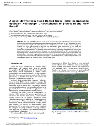
A novel downstream Flood Hazard Grade Index incorporating upstream Hydrograph Characteristics to predict Debris Flow Runoff
The July 2020 debris flow in Japan caused enormous damage, and briefing sessions on disaster prevention have prompted demands for detailed explanations and predictions of such phenomena in high-risk areas. It is necessary to obtain four-dimensional risk information, which considers temporal changes in disaster risk, rather than limiting the analysis to conventionally static information. In this study, we developed a method for setting the boundary conditions necessary for debris flow prediction via a four-dimensional hazard map using various types of digital information. To understand the effects of hydrograph characteristics from the upstream, flow discharge was analysed under different flow conditions, such as topography-driven riverbed shear stress, using a one-dimensional numerical model that considers water and sediment flow. Our results suggested that characteristics of the upstream inflow hydrograph affect flood runoff processes downstream; therefore, we developed a separate downstream flood hazard grade index that uses characteristics of the upstream inflow hydrograph as input.
006
Simulating two-phase debris flows in HEC-RAS at Hummingbird Creek, British Columbia, Canada
Debris flows are typically modelled as a single homogeneous surge due to lack of data to support more complex model development and due to lack of time and funding for the practitioner and the communities they aim to support. Coarse debris flows are typically characterized by a coarse front, followed by a muddy slurry, that is then followed by a hyperconcentrated flow phase with lesser sediment concentrations. Presented herein is the modelling for a debris flow hazard assessment for Hummingbird Creek, British Columbia, Canada. Model calibration best matched the observed debris flow deposit when the coarse front and hyperconcentrated flow were modelled separately in two phases allowing for separate flow rheologies to be used for the front and the tail of the debris flow, and allowing for deposition between phases. Further research is needed to understand when simulation of two-phase flow may be most representative, particularly when no calibration data is available.
007
Reconstruction of debris flow in the Gerkhozhan-Su river valley based on the chain modeling
The paper presents the reconstruction of the most catastrophic debris flows in the Gerkhozhan-Su river valley (North Caucasus, Russia) based on a chain of mathematical models. Transport-shift model was applied for 6 sections of debris flow formation or intense material increment, while for the rest the FLO-2D hydrodynamic model was used. A number of numerical experiments were carried out in the transport-shift model for a section of a debris flow origination site with a change in the parameters of a potential debris flow-forming soils, such as initial moisture content and density. According to the simulation results, with a rise in moisture content, the maximum debris flow discharge can increase by about 2.8 times. Modeling of debris flow in the Gerkhozhan-Su river valley was conducted for the case of low density debris flow. Based on the results, debris flow wave hydrographs were obtained at 12 sections. The results of modeling are in general agreement with the commonly accepted reconstructed pattern of the debris flow in 2000 and values obtained by videomaterials.
008
The Emerging Widespread Debris Flow Disasters in Tropical Terrain of Peninsular Malaysia: Understanding the Risk and Policy Intervention
Several widespread debris flow disasters stroke Peninsular Malaysia in between 2021 and 2022, scattered across the country. It was the first time for this hazard being nationally recognised as a type of geological disaster in the country. Debris flow disaster is not a new phenomenon. It had been recorded since 1995, however, in the past they were isolated incidents and did not attract much attention. The recent widespread debris flow disasters started in Gunung Jerai, Kedah on 18 August 2021; followed by similar incidents but in 3 different states concurrently in (1) Bentong, Pahang, (2) Hulu Langat, Selangor, and (3) Jelebu, Negeri Sembilan on 18 December 2021; Kenyir, Terengganu on 27 February 2022; and finally at Gunung Inas, Kedah on 4 July 2022. These disasters sparked numerous technical and social issues where heated debates on whether they were purely due to natural processes or caused anthropogenic activities. Previously, debris flow phenomena in Malaysia were so rare, that the term ‘debris flow’ was not familiar to the lay public. The term of “debris flow” was often disregard or used interchangeable with ‘water surge’ phenomena by the media and public, especially for sudden sediment water surge from hilly upstream after intense rainfall at hillside river catchment areas, normally occurs during the monsoon season. The ordinary water surge has significantly lesser level of destruction and momentum as compared to a debris flow with higher debris-type sediments. This paper discusses the emerging issues of debris flow in Malaysia and some initiatives being carried out in in facing the geohazard. The Department of Mineral and Geoscience Malaysia and a team of local geohazard experts have taken the lead to carry out studies to understand the sudden emergence of widespread and cascading debris flow events in Malaysia. As a result, proposal on policy intervention was put forward to the relevant government ministries; post-disaster programme has been continuously carried out to educate the communities on the geological disaster risks through community-based disaster risk management (CBDRM).
009
Definition of Rainfall Thresholds for Shallow Landslides in Colombian Tropical Mountainous Catchments as Debris Flow Triggering Mechanism
As a cascade precursor of the Debris Flow phenomenon, landslides generate economic losses and human fatalities worldwide, especially in mountainous and tropical countries like Colombia. This work proposes two different methodologies of defining rainfall thresholds as a tool for Early Warning Systems for Debris Flow occurrence in Colombian urban and mountainous catchments: Empirical-Statistical and Physically based. Empirical-Statistical rainfall thresholds are defined using several data sources such as rain gauges (pluviometers), radar, and satellite data allowing a different timing and spatial resolution in the definition. The definition of physically based rainfall thresholds the TRIGRS software is used in mountainous catchments with rainfall data from rain gauges, with the information from the safety factor map resulting in the simulations calculated as the cumulative density function from the histogram of the distributed safety factor allowing the understanding of how the instability varies in a catchment during different storms events
010
A Study on the Comparative Analysis of the FLO-2D Model According to Debris Flow Sediment Amount
It is very important to predict the extent of the damage in order to reduce or prevent damage by the debris flow. In the Republic of Korea, various methods are used to understand the characteristics and to estimate the occurrence of the debris flow in an undamaged area, such as simulating disasters using the estimation of debris flow sediment amount based on field survey data. In this study, the runout distance of debris flow was analyzed by using different methods for estimating the debris flow sediment amount, at Wondeok-eup, Samcheok-si, Gangwon-do, where debris flow occurred due to Typhoon Mitak in 2019. The simulation results of the damage area were compared with the actual damage area. The result showed that the simulations generally corresponded to the actual area of damage caused by the sedimentation of debris flow. However, the estimation of damage area varied according to the used method of calculating the debris flow sediment amount.
011
Impact of climate change on hydro-meteorological trigger conditions for debris flows in Austria
Debris-flow activity is expected to change in a future climate. In this study we connect a susceptibility model for debris-flows on a regional scale with climate projections until 2100. We use this to assess changes of hydro-meteorological trigger conditions for debris flows in six regions in the Austrian Alps. We find limited changes on an annual basis, but distinct changes when separating between hydro-meteorological trigger types and regions. While regions in the east and in the south of Austria may experience less days susceptible to debris flows in summer, there is a general trend of increasing susceptibility earlier in the year for both, rainfall-related and snow-related trigger conditions. The outcomes of this study serve as a basis for the development of adaption strategies for future risk management from this debris-flow hazard.
012
Proposal of Hazard Connectivity Index for debris flow disaster management
The concept of connectivity and its index have been widely discussed and applied to environmental studies such as ecology, hydrology, geomorphology and hydrosedimentology. Supposing that this concept is very useful also in disaster risk management, we define the hazard connectivity associated to debris flows as the connectivity degree between the debris flow occurrence (trajectory) and the point of interest (location of house, person, and so on). Based on this definition, the Hazard Connectivity Index (HCI) associated to debris flow is proposed as: HCI = L/(x+L), where x is the shortest distance between the debris flow trajectory and the point of interest; and L is the runout distance of the debris flow or just mass movement. The HCI value varies from 0 to 1, being that its higher value indicates larger hazard condition. The HCI application to one case study showed that it can be useful in the analysis of the debris flow related hazard.
013
Keynote lecture. Towards reliability-management for debris flow risk assessment
Recent progress in data-integrated simulation methods excelled our understanding of debris flows including triggering mechanisms and dynamic run-out behavior. Research groups and geohazard practitioners worldwide successfully integrate advanced simulations into workflows for hazard mapping. However, many challenges remain in predictively applying such tools for accepted decision support. One reason is our lack of a systematic approach to managing the simulations’ reliability. In this contribution, we present results on an investigation to which extent the choice of data used for calibration influences the simulation’s reliability. We start with introducing building blocks of a modular and extendible data-integrated debris flow simulation toolchain developed by our group. Next, we introduce reliability as one quality measure of a holistic debris flow simulation and discuss how it can be assessed. Based on a synthetic example, we then show how different types of observed calibration data, such as impact area, deposit volume or localized velocity measurements impacts on the subsequent forward simulation’s posterior probability distribution, hence the simulation’s reliability. We conclude by discussing how linking a debris flow simulation’s reliability to type, scope and resolution of the calibration data could offer a novel pathway towards reliability management for debris flow risk assessment.
014
Field Investigation of Sandstone Escarpment Stability at East Mountain, Utah, USA
During the last three decades, a significant amount of research has been directed to developing predictive tools for assessing the stability of the Castlegate Sandstone escarpment, travel distances for the debris and the need for any control measures in Central Utah. The cliff-forming Castlegate Sandstone is 60 m thick at the study mine in Utah and lies approximately 250 m above multiple-seam coal reserves. To assess escarpment stability, the authors used multiple regression analysis and extensive data on geology, mining, and escarpment stability collected over many years. The volume of failed rocks was used as the response variable. Mine layout options were developed to minimize cliff instability and frequency of mining-induced surface fractures. Geologic and geometric variables were obtained along 3.7 km of escarpment exposure at 180 study locations. A regression analysis of data from 29 study locations showed that surface topography plays a critical role in influencing escarpment stability. With additional data collected over the next longwall block, important variables were identified including canyon slope, thickness of Castlegate Sandstone and mining influence angle. Finally, the model was used for prediction of escarpment stability in area 3. In remote mining areas of Utah, warning signs were posted at the study areas.
015
Morphological characteristics of drainage networks related to landslide cluster in the Colombian Andean
Debris flows are a highly destructive and common phenomena in Colombia. A large percentage are triggered during seasonal rainfalls. And the Andean region is the most affected area, which exhibits a dynamic landscape made up of weak and highly weathered materials and affected by tectonic stress. As a result of this setting, sometimes many landslides are generated in clusters. Those hillslope landslides are the sediment source for the formation of debris flows. The main goal of this study is to know the state of the dynamics of 3 basins that have been affected by cluster landslides and their subsequent debris flows that have occurred in the northern region of the Colombian Andes using diverse morphometric indices. In general terms, the results show a transitory state into basins, with an evident migration along the margins of the network drainages due to unbalance state. This means more susceptible areas with greater geomorphodynamic activity.
016
Integration of meteorology and geomorphology for enhanced understanding of post-fire debris-flow hazards
Through precipitation, the fields of meteorology and geomorphology are fundamentally linked, thus interdisciplinary efforts are needed to advance understanding and warning of rainfall-driven geohazards. With a focus on recent efforts specific to post-fire debris flows in California, our presentation provides an overview of the benefits and challenges of working in an interdisciplinary team of meteorologists and geomorphologists, as well as results of a recent project demonstrating advancement through the integration of these fields. In this project, we combine high-resolution ensemble precipitation forecasts with post-fire debris-flow models to explore the feasibility and potential value of providing probabilistic post-fire debris-flow hazard information over a burn scar. In sharing these examples, we emphasize the multi-benefit nature of these efforts, and encourage future interdisciplinary efforts that improve warning and mitigation of rainfall-driven geohazards.
017
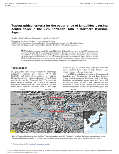
Topographical criteria for the occurrence of landslides causing debris flows in the 2017 torrential rain in northern Kyushu, Japan
In the volcanic rock fields around Hita City, 19 landslides occurred in the 2017 torrential rains in northern Kyushu, 11 of which triggered debris flows. In order to mitigate debris flows disasters caused by landslides, it is important to assess the points where landslides are most likely to occur. Therefore, topographic profiles of landslide and non-landslide slopes were calculated from digital elevation models obtained before the disaster. The results indicate that there is a topographic criterion for landslide occurrence in the relationship between the topographic position index (TPI) and the tangent Laplacian.
018
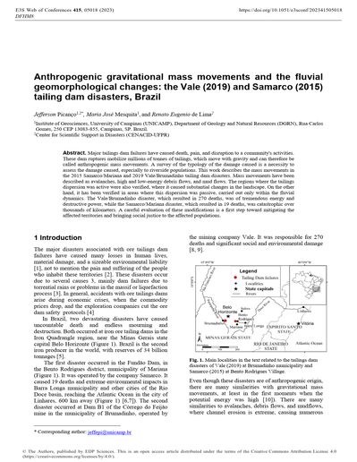
Anthropogenic gravitational mass movements and the fluvial geomorphological changes: The Vale (2019) and Samarco (2015) tailing dam disasters, Brazil
Major tailings dam failures have caused death, pain, and disruption to a community’s activities. These dam ruptures mobilize millions of tonnes of tailings, which move with gravity and can therefore be called anthropogenic mass movements. A survey of the typology of the damage caused is a necessity to assess the damage caused, especially to riverside populations. This work describes the mass movements in the 2015 Samarco/Mariana and 2019 Vale/Brumadinho tailing dam disasters. Mass movements have been described as avalanches, high and low-energy debris flows, and mud flows. The regions where the tailings dispersion was active were also verified, where it caused substantial changes in the landscape. On the other hand, it has been verified in areas where this dispersion was passive, carried out only within the fluvial dynamics. The Vale/Brumadinho disaster, which resulted in 270 deaths, was of tremendous energy and destructive power, while the Samarco/Mariana disaster, which resulted in 19 deaths, was catastrophic over thousands of kilometers. A careful evaluation of these modifications is a first step toward mitigating the affected territories and bringing social justice to the affected populations.
019
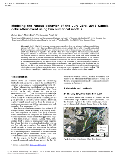
Modeling the runout behavior of the July 23rd, 2015 Cancia debris-flow event using two numerical models
On 23 July 2015, a typical volume-enlarging debris flow was triggered by heavy rainfall that occurred a few days before the event. The available data corresponding to this event is obtained from detailed field investigations conducted before and after the event, as well as the monitoring station installed in June 2014. This study aims to reproduce the July 23 debris-flow event using two different numerical methods, analyse the influence of entrainment on the runout behavior of the debris flow and compare the performance of different numerical methods when simulating the same debris-flow event. The results showed the following: (1) The expanded inundated area and unrealistic overflowing were observed in the scenario without entrainment while the simulation that takes entrainment into account presented more perfect results. It illustrates that entrainment is a non-negligible factor for the simulation of these volume-enlarging debris flows. (2) Two models considering the entrainment performed a good match between the simulation and the field survey. However, some noticeable differences can be observed in terms of the erosion-deposition distribution because different numerical schemes were adopted in the two models. Specifically, the DAN3D code always gives higher mobility and larger lateral spreading relative to the Shen model.
020
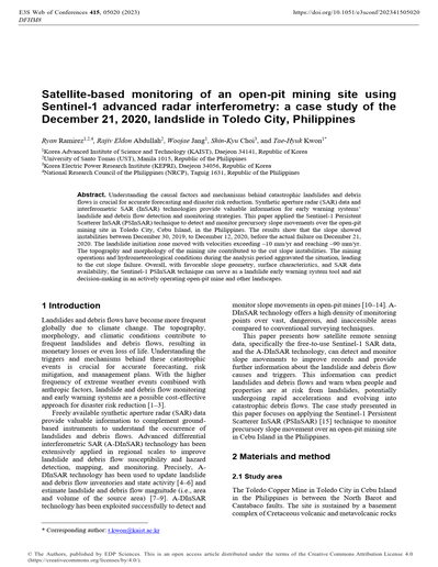
Satellite-based monitoring of an open-pit mining site using Sentinel-1 advanced radar interferometry: A case study of the December 21, 2020, landslide in Toledo City, Philippines
Understanding the causal factors and mechanisms behind catastrophic landslides and debris flows is crucial for accurate forecasting and disaster risk reduction. Synthetic aperture radar (SAR) data and interferometric SAR (InSAR) technologies provide valuable information for early warning systems’ landslide and debris flow detection and monitoring strategies. This paper applied the Sentinel-1 Persistent Scatterer InSAR (PSInSAR) technique to detect and monitor precursory slope movements over the open-pit mining site in Toledo City, Cebu Island, in the Philippines. The results show that the slope showed instabilities between December 30, 2019, to December 12, 2020, before the actual failure on December 21, 2020. The landslide initiation zone moved with velocities exceeding –10 mm/yr and reaching –90 mm/yr. The topography and morphology of the mining site contributed to the cut slope instabilities. The mining operations and hydrometeorological conditions during the analysis period aggravated the situation, leading to the cut slope failure. Overall, with favorable slope geometry, surface characteristics, and SAR data availability, the Sentinel-1 PSInSAR technique can serve as a landslide early warning system tool and aid decision-making in an actively operating open-pit mine and other landscapes.
021
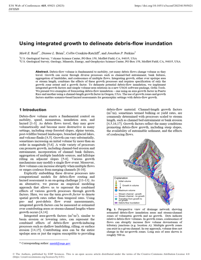
Using integrated growth to delineate debris-flow inundation
Debris-flow volume is fundamental to mobility, yet many debris flows change volume as they travel. Growth can occur through diverse processes such as channel-bed entrainment, bank failures, aggregation of landslides, and coalescence of multiple flows. Integrating growth, either over upslope area or stream length, combines the effects of these growth processes and requires specification of only the growth zone extent and a growth factor. To delineate potential debris-flow inundation, we implement integrated growth factors and simple volume-area relations in a new USGS software package, Grfin Tools. We present two examples of forecasting debris-flow inundation – one using an area growth factor in Puerto Rico and another using a channel-length growth factor in Oregon, USA. The use of growth zones and growth factors enables scenario-based hazard assessments for geomorphic settings with debris-flow growth.
022
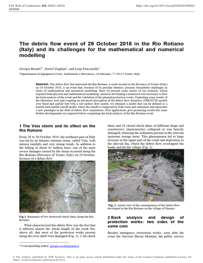
Keynote lecture. The debris flow event of 29 October 2018 in the Rio Rotiano (Italy) and its challenges for the mathematical and numerical modelling
The debris flow that interested the Rio Rotiano, a creek located in the Province of Trento (Italy) on 29 October 2018, is an event that, because of its peculiar features, presents formidable challenges in terms of mathematical and numerical modelling. Here we present some results of our research, which required both physical and mathematical modelling, aimed at developing a numerical tool necessary to face the back analysis of the event and the validation of the planned protection works. Exploiting some results of the laboratory tests and coupling an advanced description of the debris flow dynamics (TRENT2D model) over fixed and mobile bed with a sub-surface flow model, we obtained a model that can be defined as a mobile-bed rainfall-runoff model, where the runoff is composed by both water and sediments and represents a new paradigm in the field of debris flow simulations. First applications give promising results but some further developments are required before completing the back analysis of the Rio Rotiano event.
023
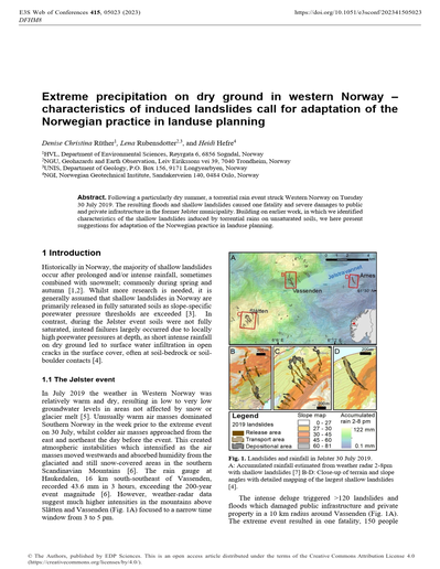
Extreme precipitation on dry ground in western Norway – characteristics of induced landslides call for adaptation of the Norwegian practice in landuse planning
Following a particularly dry summer, a torrential rain event struck Western Norway on Tuesday 30 July 2019. The resulting floods and shallow landslides caused one fatality and severe damages to public and private infrastructure in the former Jølster municipality. Building on earlier work, in which we identified characteristics of the shallow landslides induced by torrential rains on unsaturated soils, we here present suggestions for adaptation of the Norwegian practice in landuse planning.
024
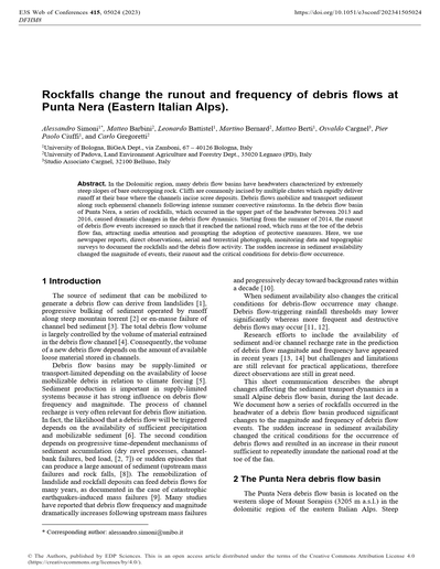
Rockfalls change the runout and frequency of debris flows at Punta Nera (Eastern Italian Alps)
In the Dolomitic region, many debris flow basins have headwaters characterized by extremely steep slopes of bare outcropping rock. Cliffs are commonly incised by multiple chutes which rapidly deliver runoff at their base where the channels incise scree deposits. Debris flows mobilize and transport sediment along such ephemeral channels following intense summer convective rainstorms. In the debris flow basin of Punta Nera, a series of rockfalls, which occurred in the upper part of the headwater between 2013 and 2016, caused dramatic changes in the debris flow dynamics. Starting from the summer of 2014, the runout of debris flow events increased so much that it reached the national road, which runs at the toe of the debris flow fan, attracting media attention and prompting the adoption of protective measures. Here, we use newspaper reports, direct observations, aerial and terrestrial photograph, monitoring data and topographic surveys to document the rockfalls and the debris flow activity. The sudden increase in sediment availability changed the magnitude of events, their runout and the critical conditions for debris-flow occurrence.
025
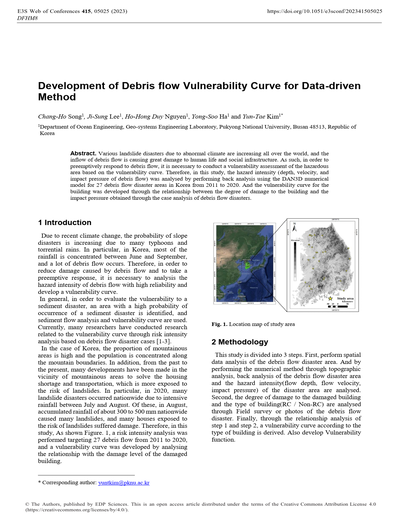
Development of Debris flow Vulnerability Curve for Data-driven Method
Various landslide disasters due to abnormal climate are increasing all over the world, and the inflow of debris flow is causing great damage to human life and social infrastructure. As such, in order to preemptively respond to debris flow, it is necessary to conduct a vulnerability assessment of the hazardous area based on the vulnerability curve. Therefore, in this study, the hazard intensity (depth, velocity, and impact pressure of debris flow) was analysed by performing back analysis using the DAN3D numerical model for 27 debris flow disaster areas in Korea from 2011 to 2020. And the vulnerability curve for the building was developed through the relationship between the degree of damage to the building and the impact pressure obtained through the case analysis of debris flow disasters.
026
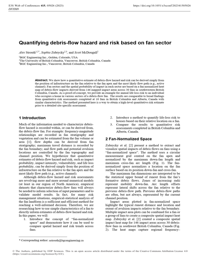
Quantifying debris-flow hazard and risk based on fan sector
We show how a quantitative estimate of debris-flow hazard and risk can be derived simply from the position of infrastructure on the fan relative to the fan apex and the most likely flow path (e.g., active channel). Fan sectors and the spatial probability of impact in each sector are based on a fan-normalized heat map of debris-flow impacts derived from 146 mapped impact areas across 30 fans in southwestern British Columbia, Canada. As a proof-of-concept, we provide an example for annual life loss risk to an individual who occupies a home in various sectors of a debris-flow fan. The results are comparable to broad findings from quantitative risk assessments completed at 10 fans in British Columbia and Alberta, Canada with similar characteristics. The method presented here is a way to obtain a high-level quantitative risk estimate prior to a detailed site-specific assessment.
027
Spatial Variation in Specific Sediment Discharge Volume from First-Order Catchment due to Heavy Rainfall and its Factors
In this study, we evaluated the variations in sediment discharge between basins from the first- order catchment of the Akatani River watershed, where sediment discharges as a result of heavy rainfall. We tested the correlation between sediment discharge, topography, and rainfall magnitude using LiDAR datasets. The results showed that the specific eroded sediment volume in the first-order catchment was sufficiently greater than the specific deposited sediment volume, and the variation of the specific discharge sediment volume from the first-order catchment was determined by the variation of the specific eroded sediment volume. The spatial variations of specific discharged sediment volumes could not be evaluated solely by topography and rainfall indices; even in the catchment, where the topographic condition and rainfall magnitude were almost the same, the specific sediment discharge varied by more than one magnitude.
028
Debris flows and debris avalanches initiation and runout susceptibility assessment in Campania region (Italy)
Sectors of the Campania region (southern Italy), where pyroclastic airfall deposits cover carbonate slopes, have frequently experienced debris avalanches and debris flows. These landslides are triggered by heavy rainfall and in the last century caused severe destruction and hundreds of deaths. Their occurrence is controlled by the interaction of several factors, both natural and human induced. The initial failure is linked with the presence of morphological discontinuities such as rocky scarps and road cuts, which interrupt the stratigraphical continuity of an “infinite slope”. Here the main criteria for susceptibility analysis are defined trying to develop a procedure for identify highly-susceptible sources, runout and invasion areas.
029
Advancing debris flow hazard and risk assessments using debris flow modeling and radar derived rainfall intensity data
Debris flow hazard and risk assessments are critical tools in mitigating and planning for these events. Existing debris flow hazard assessments can provide a rapid view of the likelihood of debris flows in recently burned watersheds and along stream segments within the watershed. Furthermore, debris flow volumes can be predicted for these watersheds and along the stream segments. Advances in modeling and remote-sensing data can add further value to the rapid assessments. Here, modeled debris flow volumes and a more detailed understanding of rainfall conditions highlight a need to reconcile debris flow probabilities and volumes using local conditions. Modeled debris flow volumes are consistently lower than even the lowest predicted volumes from empirical models used in the debris flow hazard assessments. Watershed probability and volume relations also over predict based on our probabilities derived from rainfall intensity from Multi-Radar/Multi-Sensor System 1-hr data. Probability and volume measures need to be further considered as the conservative measures of the rapid assessments have implication for risk analyses required for planning and management decisions, and ultimately for design and cost of mitigation to manage risk.
030
Probabilistic Prediction Method of Erosion Volume and Deposition Area from Rainfall Observation Data
We propose a methodology to estimate the spatial distribution of the probability of sediment deposition due to debris flow from rainfall data by combining the probability prediction of erosion volume based on an ordinal logistic regression and a sediment transport simulation. By using the Receiver Operating Characteristic (ROC) curve and Area Under Curve (AUC) we have selected the best combination of shortand long-term rainfall indices used as explanatory variables in the ordinal logistic model. The results showed that the regression model using 60-minute and 48-hour rainfall indices performed well and that the regression model using three events improved the predictability of local disasters in 2014. Furthermore, we performed Monte Carlo debris-flow simulations using rainfall data from 2014 using the model. We confirmed that the spatial distribution of disaster probability is consistent with the actual damage.
031
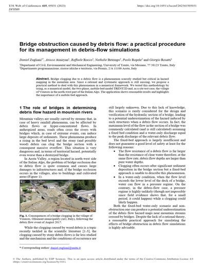
Bridge obstruction caused by debris flow: A practical procedure for its management in debris-flow simulations
Bridge clogging due to a debris flow is a phenomenon scarcely studied but critical in hazard mapping in the mountain area. Since a rational and systematic approach is still missing, we propose a practical method to deal with this phenomenon in a numerical framework. We tested this methodology by using, as a numerical model, the two-phase, mobile-bed model TRENT2D and, as a site test case, the village of Voueces in the north-west part of the Italian Alps. The application shows reasonable results and highlights the importance of a mobile-bed approach.
Engineering and Mitigation
001
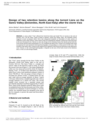
Design of two retention basins along the torrent Liera on the Gares Valley (Dolomites, North East Italy) after the storm Vaia
A storm called “Vaia” affected the North East Italy and South West of Austria at the end of October 2018. On the Gares Valley (Canale d’Agordo, North East Italian Alps), the abundant runoff triggered several in-channel debris flows that transported hundreds of thousands of cubic meters of sediments on the valley bottom. Some control works for retaining the sediment volume have then been built in the most threatened sites. Herein we show the design of two retention basins that should protect both the Liera torrent and the main road parallel to it. We computed the debris-flow volume to be retained both using an empirical law and simulated solid-liquid hydrographs corresponding to a return period of 300 years. The estimate of the debris-flow volume in the empirical law depends on the basin area upstream of the deposition zone, whereas, in the solid-liquid hydrographs, it depends on the area of the basin closed at the initiation area, as well as on the design rainfall.
002
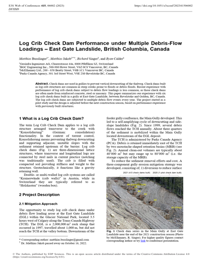
Log Crib Check Dam Performance under Multiple Debris-Flow Loadings – East Gate Landslide, British Columbia, Canada
Check dams are used in gullies to prevent vertical downcutting of the thalweg. Check dams built as log crib structures are common in steep creeks prone to floods or debris floods. Recent experience with performance of log crib check dams subject to debris flow loadings is less common, as those check dams are often made from reinforced concrete, steel or masonry. This paper summarizes our experience with six log crib check dams built in a gully at East Gate Landslide, between Revelstoke and Golden, BC, Canada. The log crib check dams are subjected to multiple debris flow events every year. The project started as a pilot study and the design is adjusted before the next construction season, based on performance experience with previously built structures.
003
Keynote lecture. Modelling flow-landslides impact against protection structures
Dynamic impact of flow-like landslides against protection structures calls for a sound understanding of the interaction mechanisms. In fact, despite a large variety of flow-landslides, there is also a significant availability of several types of protection works and many different modelling approaches, which have been customized to the specific classes of flow-landslides and protection structurers. Some remarks are reported below in a design-oriented engineering framework.
004
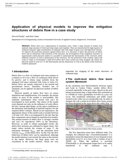
Application of physical models to improve the mitigation structures of debris flow in a case study
Debris flows are a phenomenon in mountains areas, where a large amount of mobile rock material, large amounts of water and steep slopes meet together. They are characterized by high capacity of sediment transport, high concentration of sediment with wide range of grain sizes and high front-velocity. To improve the protection measures against debris flow, it is necessary to know the processes of debris flows and its interaction with structures of the measures. By investigation of the mitigation structures in experimental scaled physical models it is possible to understand the functionality of the structures under different scenarios as well as optimization of the structures. For the protection of the counties Agarn und Leuk in Valais in Switzerland a multi-level debris flow basin system has been designed. By means the physical model in scale of 1:55 the functionality and the dimensions as well as the details of the structures could be optimized.
005
Debris flow mitigation by using biopolymers as a soil stabilizer
Towards rising the attention to the use of green materials in geotechnical applications, this study aims to introduce carrageenan as a new environment-friendly polymer for slope surface stabilization. A set of experiments were conducted to evaluate the performance of the biopolymer-treated soil to form a resistant surface against the surface erosion and debris flow. samples were tested by changing a variety of effective parameters including biopolymer content, moisture content, curing time, soil type, and durability under wet- dry cycles. Kaolinite soil along with river sand in different combinations were employed and treated by various biopolymer proportions to optimize the biopolymer and soil parameters. Subsequently, the optimum mixture of each biopolymer-treated soil was subjected to 5 cycles of wetting and drying. A broad microstructural study by performing FTIR analysis and scanning electron microscopy (SEM) images was conducted and an analytical model was developed to clarify how biopolymer stabilize the slope surface. The results confirm the successful performance of carrageenan in connecting soil grains, increasing mechanical strength and durability of soil against surface erosion. It can be concluded that carrageenan can be considered as a sustainable alternative to conventional materials such as cement and lime.
006
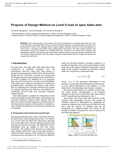
Propose of Design Method on Level II load of open Sabo dam
This study presents a load model of the Level II design for a steel pipe open Sabo dam. The Level II design is associated with a lower occurrence frequency than the conventional design concept, to the performance of debris flow trapping efficacy against higher discharge caused by heavy precipitation in recent years. A dynamic load model reveals experimental observations, and static models similar to the conventional design load models are evaluated from the viewpoint of a rational load. Dynamic and elastoplastic analyses are conducted for one structure, and three types of basin area models utilized Level II load models using a dynamic load. The safety evaluation results confirm that the design load models are composed of each other.
007
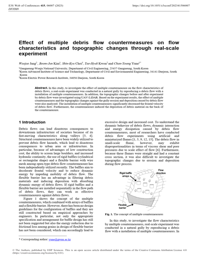
Effect of multiple debris flow countermeasures on flow characteristics and topographic changes through real-scale experiment
In this study, to investigate the effect of multiple countermeasure on the flow characteristics of debris flows, a real-scale experiment was conducted in a natural gully by reproducing a debris flow with a installation of multiple countermeasures. In addition, the topographic changes before and after experiment by debris flow were investigated using UAV-LiDAR. Based on the experiment results, the effect of multiple countermeasures and the topographic changes against the gully erosion and deposition caused by debris flow were also analyzed. The installation of multiple countermeasures significantly decreased the frontal velocity of debris flow. Furthermore, the countermeasure induced the deposition of debris material on the back of the countermeasure.
008
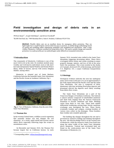
Field investigation and design of debris nets in an environmentally sensitive area
Flexible debris nets are an excellent choice for emergency debris protection. They are lightweight, have a small footprint, and are relatively easy to construct. Available design methodology based on testing and modelling makes engineering simplified with straightforward calculations. After a huge wildfire, Montecito, California sustained devasting debris flows. The need to quickly design and construct protection was made possible proven methodologies under difficult environmental restrictions.
009
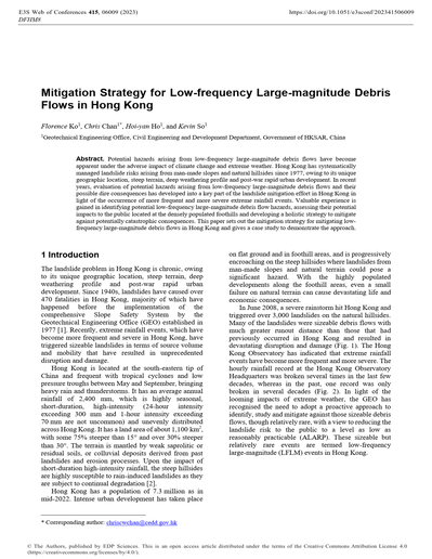
Mitigation Strategy for Low-frequency Large-magnitude Debris Flows in Hong Kong
Potential hazards arising from low-frequency large-magnitude debris flows have become apparent under the adverse impact of climate change and extreme weather. Hong Kong has systematically managed landslide risks arising from man-made slopes and natural hillsides since 1977, owing to its unique geographic location, steep terrain, deep weathering profile and post-war rapid urban development. In recent years, evaluation of potential hazards arising from low-frequency large-magnitude debris flows and their possible dire consequences has developed into a key part of the landslide mitigation effort in Hong Kong in light of the occurrence of more frequent and more severe extreme rainfall events. Valuable experience is gained in identifying potential low-frequency large-magnitude debris flow hazards, assessing their potential impacts to the public located at the densely populated foothills and developing a holistic strategy to mitigate against potentially catastrophic consequences. This paper sets out the mitigation strategy for mitigating low-frequency large-magnitude debris flows in Hong Kong and gives a case study to demonstrate the approach.
010
Deciphering controls for the impact of geophysical flows on a flexible barrier: Insights from coupled CFD-DEM modeling
Geophysical flows impacting a flexible barrier can create complex flows and solid-fluid-structure interactions, which are challenging to quantify and characterize towards a unified description. Here, we examine the common physical laws of multiphase, multiway interactions during debris flows, debris avalanches and rock avalanches against a flexible barrier system using a coupled computational fluid dynamics and discrete element (CFD-DEM) method. This model captures essential physics observed in experiments and fields. The bi-linear, positive correlations are found between peak impact load and Fr or maximum barrier deflection, with inflection points due to the transitions from trapezoid- to triangle-shaped dead zones. Our findings quantitatively elucidate how flow materials (wet versus dry) and impact dynamics (slow versus fast) control the patterns of the identified bi-linear correlations. This work offers a physics-based reference and insights for improving widely-used impact solutions for geophysical flows against flexible barriers.
011
Analysis of mitigation effect of the open- and closed-type check dam
Debris flow caused by intense rainfall can damage facilities and endanger human life. Accordingly, several models have been developed to predict and mitigate the debris flow damage, for which check-dam construction is essential. There are two types of check dams: open type and closed type. The former is suitable for granular debris flow containing little water, whereas the latter is suitable for water-laden debris flows. However, it is challenging to site the check dam to realize optimal mitigation effects. Therefore, we determined the best check dam location to reduce debris flow damage considering the two types. In this study, we simulated the Raemian apartment basin for the Mt. Umyeon landslides, which occurred in 2011. Constructing the open- and closed type dam at the upper side of the catchment produced the best performance.
012
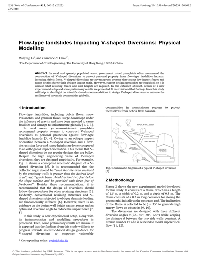
Flow-type landslides Impacting V-shaped Diversions: Physical Modelling
In rural and sparsely populated areas, government issued pamphlets often recommend the construction of V-shaped diversions to protect personal property from flow-type landslides hazards, including debris flows. V-shaped diversions are advantageous because they attract low impact forces and runup heights due to their oblique impact angle. However, current design approaches are empirical, so it is unclear what resisting forces and wall heights are required. In this extended abstract, details of a new experimental setup and some preliminary results are presented. It is envisioned that findings from this study will help to shed light on scientific-based recommendations to design V-shaped diversions to enhance the resiliency of mountain communities globally.
013
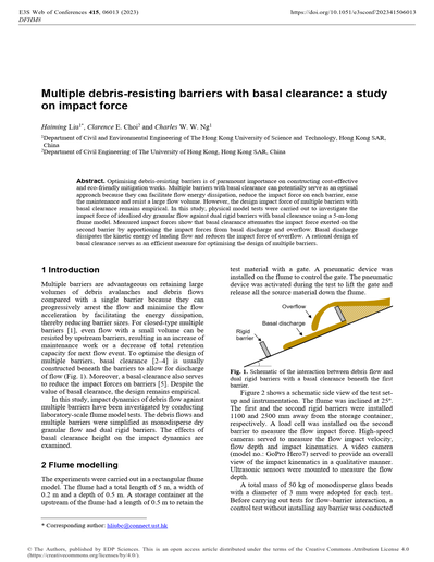
Multiple debris-resisting barriers with basal clearance: A study on impact force
Optimising debris-resisting barriers is of paramount importance on constructing cost-effective and eco-friendly mitigation works. Multiple barriers with basal clearance can potentially serve as an optimal approach because they can facilitate flow energy dissipation, reduce the impact force on each barrier, ease the maintenance and resist a large flow volume. However, the design impact force of multiple barriers with basal clearance remains empirical. In this study, physical model tests were carried out to investigate the impact force of idealised dry granular flow against dual rigid barriers with basal clearance using a 5-m-long flume model. Measured impact forces show that basal clearance attenuates the impact force exerted on the second barrier by apportioning the impact forces from basal discharge and overflow. Basal discharge dissipates the kinetic energy of landing flow and reduces the impact force of overflow. A rational design of basal clearance serves as an efficient measure for optimising the design of multiple barriers.
014
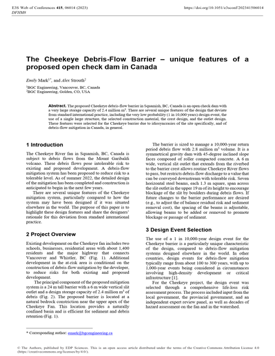
The Cheekeye Debris-Flow Barrier – unique features of a proposed open check dam in Canada
The proposed Cheekeye debris-flow barrier in Squamish, BC, Canada is an open check dam with a very large storage capacity of 2.4 million m3. There are several unique features of the design that deviate from standard international practice, including the very low probability (1 in 10,000 years) design event, the use of a single large structure, the selected construction material, the crest design, and the outlet design. These features were selected for the Cheekeye barrier due to idiosyncrasies of the site specifically, and of debris-flow mitigation in Canada, in general.
015
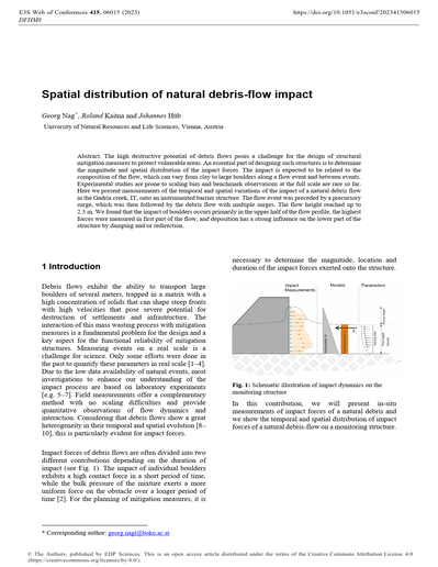
Spatial distribution of natural debris-flow impact
The high destructive potential of debris flows poses a challenge for the design of structural mitigation measures to protect vulnerable areas. An essential part of designing such structures is to determine the magnitude and spatial distribution of the impact forces. The impact is expected to be related to the composition of the flow, which can vary from clay to large boulders along a flow event and between events. Experimental studies are prone to scaling bias and benchmark observations at the full scale are rare so far. Here we present measurements of the temporal and spatial variations of the impact of a natural debris flow in the Gadria creek, IT, onto an instrumented barrier structure. The flow event was preceded by a precursory surge, which was then followed by the debris flow with multiple surges. The flow height reached up to 2.3 m. We found that the impact of boulders occurs primarily in the upper half of the flow profile, the highest forces were measured in first part of the flow, and deposition has a strong influence on the lower part of the structure by damping and/or redirection.
016
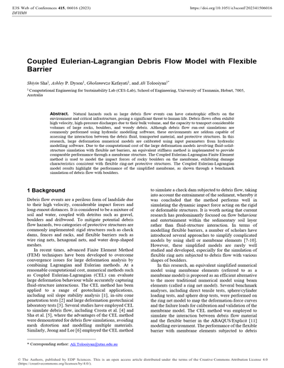
Coupled Eulerian-Lagrangian Debris Flow Model with Flexible Barrier
Natural hazards such as large debris flow events can have catastrophic effects on the environment and critical infrastructure, posing a significant threat to human life. Debris flows often exhibit high velocity, high-pressure discharges due to their bulk volume, and the capacity to transport considerable volumes of large rocks, boulders, and woody debris. Although debris flow run-out simulations are commonly performed using hydraulic modelling software, these environments are seldom capable of assessing the interaction between the debris fluid, transported material, and protective structures. In this research, large deformation numerical models are calibrated using input parameters from hydraulic modelling software. Due to the computational cost of the large deformation models involving fluid-solid-structure simulation with flexible net barriers, an equivalent stiffness method is implemented to provide comparable performance through a membrane structure. The Coupled Eulerian-Lagrangian Finite Element method is used to model the impact forces of rocky boulders on the membrane, exhibiting damage characteristics consistent with flexible ring-net protective structures. The Coupled Eulerian-Lagrangian model results highlight the performance of the simplified membrane, as shown through a benchmark simulation of debris flow with boulders.
017
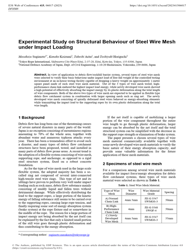
CExperimental Study on Structural Behaviour of Steel Wire Mesh under Impact Loading
In view of application to debris flow/rockfall barrier system, several types of steel wire mesh were selected to verify their basic behaviour under impact load of free fall weight at the controlled testing environment at an in-house testing facility capable of dropping a heavy weight on approximately 1-meter square panel made of such steel wire mesh material. Out of the 3 types of wire mesh tested, high-performance chain link endured the highest impact load energy, while newly developed wire mesh showed a high potential of effectively absorbing the impact energy by its plastic deformation along the total length of wire components. Both of the above two types of wire mesh are expected to be applied in flexible type debris flow catchment system in combination with larger opening mesh such as ring net. The newly developed wire mesh consisting of spirally deformed steel wires behaved as energy-absorbing elements while transmitting the impact load to the supporting ropes by its own plastic deformation along the total wire length.
018
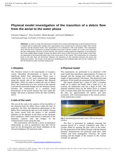
Physical model investigation of the transition of a debris flow from the aerial to the water phase
In order to study the phenomena of debris flow motion and deposition at the transition between a channel and an underwater storage area, experiments were carried out on a physical model. The current situation and the planned works were reproduced in two idealised 1:100 scale models. The experiments show that the flows experience an abrupt transition into water with the creation of a water wave and enter the lake undergoing a decrease in front velocity, but without creating upstream stagnation or local deposits due to the sudden phase change. Instead, the debris flows move to the lower part of the model, where they are deposited in the horizontal plane and in the lower parts of the conoid. The construction of a retention basin in the lake does not decisively influence the dynamics of the transition between the aerial and underwater phases. The results of the physical modelling provide indispensable data for the validation of the 3D numerical codes currently being tested.
019
Static and dynamic impact forces on a rigid barrier due to dry debris flow simulated by a DEM-based granular column collapse
Geophysical flows like debris flows require protective barriers so as to scale down their disastrous effects. The impact force exerted on these barriers depends upon several factors like the velocity and height of flowing debris, the density and other associated characteristics of flowing mass, and the height of the sediment deposited behind the barrier. These factors are found to vary with time during the debris flow process, thereby causing significant temporal variations in the magnitude of impact force. Assessing the impact force on a barrier is a prerequisite for its design. In this work, the impact of dry debris flow, emanating from a granular column collapse, on a rigid barrier has been investigated using 3-D Discrete Element Method (DEM). It has been found that the impact force is predominantly influenced by dynamic thrust at the initial stages, which, with elapse time, subsequently transits to the sole contribution of static pressure. The applicability of the existing hydraulic models comprising hydrostatic and hydrodynamic formulae has also been analysed in this exercise. Furthermore, the empirical coefficients associated with these formulae have been evaluated for the dry debris flow impacting the rigid barrier.
020

Sediment control and logs capturing in sand pocket with combination of sabo dam with large conduit and iron bars
In the Otoishi River, a tributary on right side of the Akatani River in the Chikugo River basin, a large amount of sediment and woody debris were deposited on riverbed due to the sediment disaster caused by the heavy rainfall in northern part of Kyushu Region on 5th to 6th July in 2017. As one of countermeasures to control the outflow of sediment and woody debris to the Akatani River, a sand pocket is planned with the sabo dam with large conduit parts and the log broom works. In this study, hydraulic model test and flume test were carried out to obtain knowledges for design of the sand pocket. Iron bars are installed vertically at the upstream front of the large conduit parts for capturing sediment and logs, and those intervals are desirable to be set in consideration of sediment diameter and sediment movement without the dam. Besides, it is necessary to consider capturing function and flow characteristics such as shockwave when the log broom works is planned in setting of layout and dimensions.
021
A simplified numerical model for evaluating sediment control by open-type sabo dams in the Joganji River basin
The present study proposes a method to estimate sediment runoff by introducing a dam function of the relationship between inflow sediment and sediment runoff through a slit dam. The model can process rainfall runoff, sediment yield and runoff of a mountainous basin, and the model is applied to the upper reaches of the Joganji River basin, which is known for its huge amount of sediment runoff and intense bed variation because of the sediment yield caused by the earthquake in 1858. The performance of the calculations of sediment control of the slit dam is evaluated by the model. The result indicates that sediment deposition is significantly changed by sediment runoff. The proposed method can be expected to evaluate sediment transport with sabo dams on a basin scale.
022
Keynote lecture. Impact dynamics of debris flow against slit dam: Experimental and numerical investigation
Debris flows are gravity-driven phenomena common in mountainous regions that are hazardous to downstream facilities. To mitigate the impacts of these disastrous processes, structural countermeasures such as slit dams are constructed in gullies and along mountain slopes. Existing studies on the impact dynamics of debris flows against slit dams typically focus only on the flow characteristics but fail to take the geometry of the structure into account. Here we develop an analytical model, derived from the momentum approach, that allows for the estimation of the runup height and impact load of debris flows on slit dams. The model is validated against discrete element simulations and small-scale flume experiments. It is found that the runup height is controlled by both the Froude number and slit size. The proposed analytical model can predict the runup height well within a certain range of Froude numbers. Results from experiments further reveal that the fontal dynamic pressure is sensitive to the flow properties whereas the peak dynamic pressure is strongly affected by the slit size.
Needs of End Users
001
Runout model evaluation based on back-calculation of building damage
We evaluated the ability of three debris-flow runout models (RAMMS, FLO2D and D-Claw) to predict the number of damaged buildings in simulations of the 9 January 2019 Montecito, California, debrisflow event. Observations of building damage after the event were combined with OpenStreetMap building footprints to construct a database of all potentially impacted buildings. At the estimated event volume, all models overpredict the number of damaged buildings by a factor of 1.5–3.
002
MurGame: Protect your village from debris flows!
Past debris flow events, like in Bondo (2017) and Brienz (2005) in Switzerland have been heavily covered in the (Swiss) media, illustrating how destructive such events can get. Protection measures play an important role in dealing with natural hazards. Debris flows are considered to be very rare, complex and multidimensional processes. Imagining and foreseeing the course and progression of a debris flow as well as estimating the potential damage and the influence of protection measures is a difficult task. Serious games offer a possibility to simulate these kinds of situations. With the MurGame, we have developed an application for natural hazard prevention. In the three-dimensional, interactive game, a village is created by selecting different objects, such as residential buildings or schools. Debris flow simulations show, which buildings would be destroyed and what damage would occur in the event of a debris flow. Different protection measures can be implemented to protect the village and their effectiveness can be monitored during the simulations. After the event, it is necessary to evaluate which measures offer the desired protection, what they may cost and how the needs of the population are met. The MurGame can be played online at www.murgame.ch.
003
A new statistical method to assess potential debris flow erosion
Debris-flow erosion patterns were investigated for two adjacent catchments, Molinara and Val del Lago creeks (Eastern Alps, Trento Province, Italy), where two debris flows were triggered by an intense storm in the summer of 2010. Both basins have been inactive over the last two centuries. The debris flows were activated by channel and bank erosion under stable bed conditions before the event. The erosive process was analysed by combining a field campaign (two hundred cross sections were surveyed along the creeks) and pre- and post-event LiDAR surveys. Data were analysed by selecting morphologically-homogenous channel reaches and deriving for each reach: erosion depth, creek width, eroded volume and peak discharge. Investigating the frequency distribution of the erosion depth we found out that it follows an EV1 probability distribution. On this basis, a new approach has been proposed to predict event volumes when the expected maximum potential depth erosion is known. The procedure would be of high interest in predicting debris flow volume in mountain channels characterized by long silent periods.
004
Risk Assessment of Transport Linear Infrastructures to Debris Flow
For the assessment of debris flow risk, it is essential to consider not only the triggering and propagation stages but also to perform analyses of its effects and consequences. The study aims at developing a procedure based on a quantitative risk assessments able to estimate the different levels of risk with reference to transport linear infrastructures. This includes numerical modelling for debris flows to determine the zones where the elements at risk could suffer an impact. A detailed comparison between the performances of two different approaches to debris flow modelling was carried out. In particular, the results of a mono-phase Bingham model (FLO-2D) and that of a single-phase model (RASH-3D) with reference to the Enna area (Sicily). The results can be applied for the risk calculations. The purpose is to define a priority of intervention for the identification of the infrastructures exposed at risk, leading to the choice of safety measures.
005
Debris-flow risk-to-life: Upper-bound preliminary screening
Where the potential for future debris-flow occurrence is unrecognised, developments can be unknowingly exposed to debris-flow impact, with corresponding risks to lives. Debris-flow modelling is unsuited to routine local office use, so a simple screening procedure is proposed to enable local officials to identify locations where debris flow risk-to-life may be unacceptable, and prioritise where expert modelling and risk analysis are most urgently required for risk-management decision-making . This procedure calculates catchment Melton ratio R from topographic data, uses a linear upper bound of field data relating R to the annual probability of debris-flow occurrence, and matches a model-based debris-flow risk-to-life analysis for Matata, New Zealand. Our data suggest that any development exposed to debris flows will require a detailed risk assessment to ensure that risk-to-life does not exceed acceptable levels.
006
Practical guide for debris flow and hillslope debris flow protection nets and its application in case studies
Debris flows and hillslope debris flows endanger people and infrastructures. Technical protection measures are important elements in addition to spatial planning (adapted use of space like hazard maps) and organizational measures (warning systems, emergency plan, evacuation). Additional to other rigid protection measures flexible debris flow nets and hillslope debris flow nets were developed in 2008, and 2010 respectively. Such flexible barriers consist of an interception surface of netting spanned between horizontal support ropes including energy devices and posts for large span width. Since then, they are available on the market worldwide. Many projects were successfully installed and already filled by debris flow events. After more than ten years of experience and demonstrating that these measures work against debris flow and hillslope debris flow, they are fully accepted as possible measures for integral protection against debris flow. To provide planners and engineers the experience and know-how of these flexible protection nets, a practical guide was initiated by the Swiss Federal Roads Office (FEDRO) and Swiss Federal Office for the Environment (FOEN). Two case studies with planned and installed flexible nets, in one case for a debris flow and in the other case for a hillslope debris flow, are presented.
007
A CFD-DEM Based Numerical Investigation of Debris Flow on Ballasted Railway Track
Debris flow occurring in mountainous areas can cause issues to railway tracks. Debris flow may cause large track deformation and even track breakage and introduce server ballast fouling afterwards. After the flash of a debris flow, the fine particles can be retained in the ballast layer and significantly reduce track drainage, leading to lower bearing capacity and a higher risk of track lateral stability problems. Moreover, these solid particles may deposit on the railway surface and endanger the train directly. Unfortunately, those debris flow introduced track issues have not been thoroughly investigated. This study presents a numerical investigation of the impact of the debris flow on the railway track. Various factors governing the debris flow are considered, including particle size and solid fraction. Besides, those factors affecting the ballast are also discussed, such as fouling condition and initial void ratio. A coupled computational fluid dynamics and discrete element method (CFD-DEM) approach is developed to capture the interactions between particles/particles, water/air, and particles/fluid. The results from this study may help the railway to improve track resilience before the debris flow and to improve maintenance strategy after the debris flow flashing.
008
Tensile stress development and critical behavior of a flexible barrier
A DEM numerical approach is employed to illustrate the critical stress development of a three-supporting cable flexible barrier under a large scale stony debris movement impact. A proper linear parallel bond is applied to build the flexible barrier model. Critical state is presented by lowering the tensile resistance of the flexible barrier and steepening the channel slope. The tensile stress of the supporting cables is primarily studied. Results mainly indicate that the particle-structure contact is essential to the stress development. The bottom cable always exhibits larger tensile stress due to the massive collision and compressive force of particles and the tensile force exerted by the vertical cable-net joint system. On the other hand, the intermediate cable receives lower collision and compressive force, resulting in smaller tensile stress. The bottom cable indicating numerous direct particle-structure contact part performs brittle failure, which is analogous to the concentrated load feedbacks. The loading of the intermediate one reaches ductile failure, reflecting the desirable effect of dispersing loads. This study suggests that practical engineering should try to avoid massive boulder impact or reinforce the bottom cable in order to improve the hazard prevention design.
009
Debris Flow Hazard Mapping Along Linear Infrastructure: An Agent Based Model and GIS Approach
Often linear infrastructure, including rail, highways, and pipelines, span large geographic areas intersecting a variety of terrain, predisposing infrastructure to a higher likelihood of geohazard interaction. Debris flow models can be particularly advantageous in remote hazard and risk mapping along linear infrastructure as runout from susceptible slopes may extend considerable distance downslope to a receptor. In this sentiment, a method is developed using an agent-based model, DebrisFlow Predictor, in combination with geographic information software (GIS), to produce regional debris flow hazard and risk profiles along widespread corridors. Thousands of debris flows upslope of a receptor(s) are simulated in the model environment (i.e., model scenarios). Outputs of the modelled scenarios provide probabilistic spatial attributes of debris flow runout and depth across a digital elevation model at a 5m resolution. The outputs of multiple scenarios are mosaiced and corrected to in-situ temporal and spatial debris flow initiation conditions in GIS. The corrected scenario outputs provide a comprehensive hazard profile along the infrastructure alignment, that in turn can facilitate quantified vulnerability and risk calculations. Thousands of modelled debris flows throughout several physiographic regions of Canada and the United States of America, calibrated to local conditions, provide substantive support for a novel methodology to identify key hazard and risk locations to major linear infrastructure.
010
A time-independent reliability based design approach for debris flow flexible barriers
The design of debris flow protective structures has represented a challenge since the last decades. The design process might consider several variables related to actions and resistances, mainly linked to impact pressure and dynamic pressure resistance. Debris flow events do not have always the same magnitude, and small events can occur with a high probability. Therefore, an events frequency-magnitude relationship might be considered in the design of protective structures. In the Eurocodes framework, the fixed partial safety factors design approach not considering the intrinsic site variability of these phenomena, does not allow obtaining a specific probability of failure. Reliability-based approaches reveal to be compelling solutions. Focusing on flexible barriers, the paper presents a novel time-independent reliability approach, which considers all the possible debris flow events and provides the failure probability of a barrier in a given temporal interval.
011
Keynote lecture. Defining Protection Works Against Debris-Flow Hazards: Industrial Standard, Tailor-made or Haute-couture?
Despite centuries of forestry and empirical soil conservation works as well as decades of research on debris flow processes, defining protection strategies against debris flows remains complicated. We are far from guidelines resembling an industrial standard to define the type, location and shape of debris flow protection works. We believe that this particular step will likely never be fully standardized because design engineers must have a certain degree of freedom to tailor the protection works to the astonishing varieties of catchments, geologies and geomorphologies, and the associated complex emerging debris flow regimes. Some catchments are have such specific features that defining an adapted protection strategy requires innovation: this is not even “tailor-made” but perhaps “haute-couture”. In this paper and the associated keynote lecture, we propose a possible way to approach the problem by firstly focusing on the sediment transport connectivity and the channel malfunctions leading to debris flow deposition; and secondly to select structures that prevent the latter, as well as to adjust the channel capacity to the debris flow supply.
012
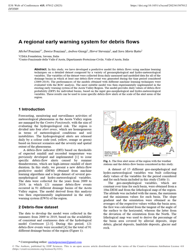
A regional early warning system for debris flows
In this study, we have developed a predictive model for debris flows using machine learning techniques on a detailed dataset composed by a variety of geomorphological and hydro-meteorological variables. The variables of the dataset were collected from daily measured and modelled data for all of the drainage basins in which at least one debris-flow event was generated during the time period considered (2009-2019). The performances of the models obtained with different machine learning techniques were evaluated with the ROC analysis. The most suitable model was then experimentally implemented in the existing early warning system of the Aosta Valley Region. The model provides daily values of debris-flow probability (DFP) for individual basins, based on the input geo-morphological and hydro-meteorological variables. These results can be used to issue specific debris-flow alerts at the scale of the alert areas of the region.
013
Modelling of debris-flow deposition: Terrain slope, mobility coefficient, and back-calculated basal friction coefficient
Numerous simulation models have become available for the hazard delineation of gravitational mass movements such as debris flows in the potential depositional area. This study compares the basal friction coefficients of two modelling approaches as they have been used in other studies to simulate mass movement deposition. We show that both back-calculated basal friction coefficients are related to the fan or terrain slope in the deposition region and to a mass flow mobility coefficient. The latter is characterized by the geometric scaling between the deposition area and the deposition volume as well as by process type. Intended as a preliminary study, we aim to initiate systematic investigations of different model applications to determine the runout pattern of mass movement processes, that could provide guidance for appropriate parameter selection.