the 6th International Conference on Debris-Flow Hazards Mitigation (Tsukuba, Japan)
TOTAL 34 papers
001
Amplification Mechanism and Hazard Analysis for Zhouqu Giant Debris Flow
A giant debris flow occurred in Zhouqu County, Gannan Tibetan Autonomous Prefecture, Gunsu Province, in the evening of 7 August 2010, causing 1765 deaths and missing, with enormous property losses. It ruined 4321 houses and caused 22,667 homeless. The stricken area at Sanyanyu debris flow was 50.0 hm2 including 3 hm2 urban area and 47 hm2 farmland. A dammed lake 2 km in length was formed in Bailongjiang River by the debris flow deposit with 8~10 m high, which blocked the river. The main urban area of Zhouqu city was inundated for one month. This tragic catastrophe raises a topic that how a giant debris flow develops from a relatively small original one in source area and what methodology can be used to identify whether a building is in danger or not. In order to understand this issue, a detailed field survey had been carried out in catchments of Sanyanyu and Loujiayu. The field survey revealed that flood in upstream eroded the debris barriers and unconsolidated soil bed in channel and developed into debris flow. The laboratory physical experiments indicated that the major mechanism of giant natural debris flows formation is scale amplification caused by cascading landslide dam failures. Another process of scale amplification is that debris flow schleps sediment from erodible channel bed. At last, a numerical technique will be developed to simulate danger area and momentum of debris flow. Based on the results of dynamic simulation, a method of hazard assessment will be established for identifying dangerous area. Hope this methodology can serve for urban management in mountainous villages and townships.
002
Debris-Flow Hazard Assessment and Methods Applied in Engineering Practice
Debris flows constitute a major natural hazard in mountainous regions. The main elements required for a practical hazard assessment include the following steps: (i) estimation of potential initiation zones and sediment sources, (ii) establishment of a relation between the magnitude and frequency of expected future debris-flow events, and (iii) assessment of the flow behavior and delineation of areas potentially endangered by flowing debris. A general overview is presented of the main triggering conditions and initiation mechanisms for debris-flow formation. A brief summary is given of methods to establish a magnitude-frequency relation and to estimate the total volume of sediments transported to the fan during so-called “design” events. To assess the runout distance of debris flows and potentially affected areas, either simple empirical approaches or more physically based numerical simulation models may be used. An example application for a Swiss debris fan illustrates the variability of the results when using three different debris-flow simulation models, even though all three models were first calibrated based on the observed deposition areas of a past event.
003
Behavior of Boulders within a Debris Flow Initiation Zone
Although it is important to understand the behavior of debris flows in the initiation zone for the development of mitigative measures, data are scarce due to difficulties in field monitoring. To clarify debris flow behavior within the initiation zone, we established a monitoring system in the upper Ichinosawa catchment within the Ohya landslide, central Japan. In the Ohya landslide, loose sediments, previously deposited on steep channel bed, is the main source of debris flow material. Video image analysis of six debris flows revealed that the largest boulders in the debris flows were usually smaller than those in the channel deposits. Thus, debris flows appear to facilitate the selective transport of channel deposits in the upper Ichinosawa catchment. Flows that occur during debris flow surges can be classified as either i) flows comprising mainly cobbles and boulders, or ii) flows comprising mainly muddy water. The duration of each flow type is different amongst debris flow events. Flows mainly composed of cobbles and boulders accounted for most of the surges when channel deposits, which were the main source of debris flow material, were abundant. In contrast, flows were mainly composed of muddy water in surges when channel deposits were scarce. The particle size of the boulders had no clear relationship with flow height, with the size of the largest boulders generally ranging from 15 to 40 cm regardless of flow heights (ranging 0-5 m). The particle size of the material entrained by the debris flow differed among debris flow events. Coarse particles were frequently found on the flow surface when the particle size of the channel deposits was larger. Therefore, the characteristics of boulders in debris flows within the debris-flow initiation zone were affected by the volume and the size of sediment at the source of the debris flow material.
004
Internal Dynamics of a Free-Surface Viscoplastic Flow Down an Inclined Channel
This paper presents preliminary experimental results concerning the internal dynamics of a free surface viscoplastic flow down an inclined channel. Experiments are conducted in an inclined channel whose bottom is constituted of an upward-moving conveyor belt with controlled velocity. Carbopol microgel was used as a homogeneous transparent viscoplastic fluid. This experimental setup allows generating and observing stationary gravity-driven surges in the laboratory frame. We used PIV technique (Particle Image Velocimetry) to obtain velocity fields both in the uniform zone and within the front zone where flow thickness is variable and where recirculation takes place. Experimental velocity profiles and determination of plug position are presented and compared to theoretical predictions based on the lubrication approximation.
005
Debris-Flow Monitoring for the Set-Up of a Warning and Alarm System -Experiences from the Pyrenees-
Debris-flow monitoring sites provide many important inputs on their mechanics and strongly improved the understanding on this hazardous process. Monitoring data are the basis for future early warning systems (EWS) and alarm systems (AS). In this study, results from the Rebaixader monitoring are presented and evaluated for the implementation in an EWS and AS at catchment scale. The key parameters are the rainfall thresholds for the warning and the ground vibration produced by the moving debris flow for the alarm emission. At regional scale, a preliminary EWS for a test area in the Central-Eastern Pyrenees is evaluated. The EWS is based on quantitative precipitation estimates obtained from the weather radars and a simple susceptibility model, which is applied in each basin of the test area. The experiences gathered in the Pyrenees show that the knowledge on initiation and flow behaviour of debris flows has strongly advanced and facilitate the set-up of operational EWS or AS. However, there are still remaining various uncertainties (especially related to the adequate definition of thresholds), which must be evaluated and continuously eliminated.
006
Methods of Data Processing for Debris Flow Seismic Warning
The output of the seismic devices commonly employed for the monitoring of debris flows, such as geophones and seismometers, is a voltage that is directly proportional to the ground vibration velocity. The output signal in analogical form is usually digitalized at a fixed sampling frequency to be opportunely processed. The processing is performed to both reduce the amount of data to be stored in a data-logger and to reveal the main features of the phenomenon that are not immediately detectable in the raw signal, such as its main front, eventual subsequent surges, the wave form and so on. The processing also allows a better and sounder development of algorithms, when seismic devices are employed for warning purposes. However, the processing of the raw signal alters in different ways the original raw data, depending on the processing method adopted. This may consequently limit or reduce the efficacy of the warning. Different methods of data processing can be found in literature, each with its own advantages and shortcomings. In this paper we will explore and discuss the effects of some of these latter on the efficacy of the algorithms employed for warning, applying them to the seismic recordings obtained in the instrumented basins of Gadria (Italy), Rebaixader (Spain) and Illgraben (Switzerland).
007
Experimental Study of Particle Size Reduction in Geophysical Granular Flows
Rock particles in debris flows and other geophysical granular flows are reduced in size through abrasion and fragmentation. A better understanding of the controls on particle wear in geophysical granular flows is needed for inferring flow conditions from flow deposits, estimating the initial size of sediments entrained in the flow, modeling flow dynamics, and mapping hazards. We used three rotating drums to create laboratory granular flows. Drum diameters range from 0.2 to 4.0 m, with the largest drum able to accommodate up to 2 Mg of debris, including boulders. We began the experiments with well-sorted, angular coarse particles in clear water. After each 0.25 km of travel distance, we quantified the particle size distribution. Rates of coarse particle wear, and production of fragments and fine particles scaled with the rate of energy expenditure per unit bed area, or unit drum power. We used this power scaling to estimate the rate of particle breakdown in a debrisflow dominated catchment in the Sierra Nevada, California.
008
Evaluation of Model Parameterization Through Laboratory Investigations
Engineering simulation tools for predicting the flow and deposition behavior of debris flows make use of simple rheologic flow laws describing flow resistance. In this contribution we test the possibility to parameterize simple flow models by laboratory investigations. We estimate parameters for the Bingham model from a suite of laboratory experiments in different setups. Material samples were taken from fresh deposits of a muddy debris flow and analyzed over a range of volumetric sediment concentrations and maximum grain sizes. Our results are relatively consistent between most setups. Estimated rheologic parameters show an exponential dependence on volumetric sediment concentration and a systematic variation for mixtures of different maximum grain sizes. Though a rheologic interpretation of bulk flow behavior seems feasible at the laboratory scale, extrapolation of rheologic parameters to prototype flow situation for direct use in numerical simulation tools is not recommended.
009
Prevention and Mitigation of Debris Flow Hazards by Using Steel Open-Type Sabo Dams
This paper presents the findings of an investigation on the prevention and mitigation of debris flow hazards by using steel open-type dams. First, the actual cases of trapping hazardous debris flow by steel open-type dams were surveyed. Through a field survey of actual cases, we classified them into four distinct scenarios based on the trapping type of debris flow: Scenario A (wooden debris + rocks + sediment), Scenario B (wooden debris + sediment), Scenario C (rocks + sediment) and Scenario D (wooden debris only). Second, recent trapping cases on protection and mitigation by various steel open dams were introduced. Third, trapping scenarios A, B, C and D were confirmed by performing physical model tests. Finally, a safety check of a steel open dam against a large rock was verified by two impact analyses, the finite element method (FEM) impact analysis using ANSYS Autodyn software, and the three dimensional (3-D) impact frame analysis.
010
Debris Flow Flooding and Debris Deposition Considering the Effect of Houses: Disaster Verification and Numerical Simulation
Debris flow causes flooding and sediment deposition when it reaches alluvial fans. Many houses have been constructed on alluvial fans, and this can affect debris flow flooding and deposition. In this study, we first conducted a field survey on recent debris flow disasters in Japan; one such disaster, the Izu Oshima sediment disaster, occurred in October 2013. Houses located upstream, in lower areas, and those facing small bridges and crossroads suffered greater damage than those located in other areas. Secondly, we performed numerical simulations using debris flow simulators (KANAKO 2D and Hyper KANAKO) to determine the effect of houses on debris flow flooding and deposition. For the simulations, grid points of the locations of houses were set taking into consideration the height of the houses from the ground elevation. We simulated typical debris flow condition and real disaster cases. The simulation results showed that when houses are present, the spread of debris flow is wide in cross-direction upstream of the houses. Houses also affect the deposition area. The presence of houses increased flooding and deposition damage in some areas, whereas it reduced damage in others. When setting the houses, the areas between the houses were set lower than the houses located at the grid points. Such areas were designated as roads, and the results showed that the flow occurred along the roads, as in real disasters.
011
Sediment Run-Out Processes and Possibility of Sediment Control Structures in the 2013 Izu-Ohshima Event
Typhoon No. 26 in 2013 attacked the Izu-Oshima Island with record heavy rainfall and caused a disaster resulting from landslides and mud flows. This extreme event is the motivation of our study on how we evaluate hazardous zones at risk of mud flows and how we design structural and non-structural measures accordingly. The present study describes sediment runout processes, mud flow control by means of a guide wall, and a method to evaluate topological conditions in which landslides and mud flows avalanche into unexpected areas. The landslides took place in the western slope of Izu-Oshima, which is only about 2500m wide. Analyses on phase shifting from solid to liquid as well as on mobility of the soil masses suggest that the soil masses released by the landslides transformed directly into mud flows, and that the mud flows developed in size through sediment erosion in their run-out processes. The predicted results by means of a numerical model based on depth-integrated governing equations of sediment-water mixture flow suggest that mud flows could be controlled well using a guide wall, which shows a high possibility of mud flow control using a storage structure with a guide wall. In addition, we propose a simple method to evaluate topological conditions to judge whether mud flows will enter unexpected areas, which will provide a key to identify hazardous zones including even those that have been missed out conventionally.
012
Development of Modified Particles Method for Simulation of Debris Flow Using Constitutive Equations
We propose a numerical simulation method for calculating the vertical distributions of the flow velocity and the sediment concentration in debris flows. Our method is based on the moving particle semi-implicit (MPS) method. We introduce the constitutive equations of Egashira et al. to the MPS method. Numerical simulations of the debris flow are performed by using an existing model based on a shallow water equation, along with our model based on the MPS method. In the condition where the riverbed gradient becomes less steep, there is good agreement with experimental results, including those involving the formation of a convex upward deposition shape in the initial deposition process. Results for the initial deposition process are not produced with existing simulation method based on a shallow water equation. Further, our model can yield clear results when the upper and lower layers have different flow directions in a numerical simulation of the collapse of a natural dam by overtopping.
013
Particle Size-Segregation and Spontaneous Levee Formation in Geophysical Granular Flows
Particle size-segregation can have an important feedback on the bulk flow of geophysical granular avalanches. As a polydisperse material travels downhill the larger particles rise to the surface, where they are preferentially sheared to the flow front. This coarse-rich region experiences a greater resistance to motion and the large particles are shouldered aside to form lateral levees. Wider flows may break down into a series of these lobate, ‘finger-like’ structures. In either case, the static leveed regions channelise the finer, more mobile interior, causing the resulting run-out distances to be significantly enhanced. Modelling segregation-mobility feedback effects is therefore crucial for hazard mitigation. A new class of depth-averaged continuum models is introduced that describes the transport of large particles as well as the granular rheology. The feedback arises from a basal friction law that is composition dependent, implying greater friction where there are more large particles. Numerical simulations are used to show the spontaneous formation of leveed fingers.
014
Field Surveys and Numerical Modeling of Pumiceous Debris Flows in Amalfi Coast (Italy)
The first objective of the work is to test a cost-effective tool for the collection of debris flows (DF) field data such as volumes, peak flow depths and deposit depths. Secondly, we show how these data can be used for the calibration of a depth-averaged propagation model. The case study is a DF of pumiceous sediments, occurred in the Amalfi Coast (Southern Italy) in October 2013. The DF path is a steep channel, ending in a small debris fan delimitated by a gabion wall. The risk is high because DFs, having a return period of just few years, overtop the wall and hit a busy road. Both terrestrial laser scanner (TLS) and photogrammetric techniques were employed to survey the topography, before and after the event under study. The images of the channel were taken from an unmanned aerial vehicle (UAV). Digital terrain models (DTM) were obtained pre and post event while the traces left by the DF along the channel banks allowed the estimation of the peak flow depths.A finite volume two-dimensional numerical code (FLATModel), based on shallow-water equations, was used for modelling the propagation and deposition of the DF under study. Both Voellmy and pure Coulomb friction resistance laws were tested. The numerically predicted deposit was compared to the post event DTM. Such comparisons showed a good agreement in terms of both depths and shape of deposit. The calibrated model could be used to predict the DFs run-out distances in similar contexts.
015
Experimental Investigation into Flow Behavior of Wood-Sediment-Water Mixture at a Grid Type of Open Check Dam
Laboratory flume experiments showed the different behavior of sediment grains and wood pieces in debris flows (wood-sediment-water mixture flows) at an open check dam model. In the experiments, the debris flows were caused by putting some wood pieces on the initial movable bed and dropping the other wood pieces on the surface of the subsequent flow part. This condition resulted in the concentration of the former pieces at the flow front and the latter pieces on the subsequent flow surface. The latter pieces trapped in the check dam model were piled up on the former pieces trapped in the check dam. The sediment followed the pieces accumulating at the flow front. At the same time, sediment deposition was caused behind the trapped wood pieces.
016
Field Measurements of Forces in Debris Flows at the Illgraben: Implications for Channel-Bed Erosion
Using a large force plate as installed in the channel bed at the Illgraben debris-flow observation station, we illustrate flow properties of three typical types of debris flow which occur there, single-surge debris flows, multiple-surge flows, and more complicated surges with many individual roll waves. In all three types of flow, the median value of the normal and shear stresses are largest at the front or fronts of each surge. Additionally, the fluctuations in normal and shear stress are also largest at the flow front, reaching values up to 1.5 times larger than the median value. The presence of large force fluctuations at the front of the surges is in agreement with previously-published results which show that the rate of erosion is largest within the first minute of the arrival of a debris-flow surge.
017
Hydrological Observation of Subsurface Flows Spouting from Pipe Exits in Torrent Bed Material and its Triggering Rainfall Conditions of the Nishinokaito River in Mount Fujiwara, Mie Prefecture, Japan
Several pipe exits were discovered in the torrent bed material in debris flow generation areas of the Nishinokaito River, Mount Fujiwara, Mie prefecture, Japan. These exits were in a sand and gravel layer between 1.0 and 1.5 m below the surface of the torrent bed material. Gravel supported the internal walls of the pipe exits. Subsurface flows spouted when the rainfall intensity exceeded 5 to 7 mm in 10 minutes and the soil water index exceeded about 110 mm. Due to hydrological processes, subsurface flows spouting at the new pipe exits during heavy rainfall may lead to debris flow generation. We studied the critical rainfall thresholds using the radial basis function network (RBFN) method.
018
Study on the Surge Wave Induced by Glacier Avalanches and its Effects on Dam Failure Process
In this article, experimental tests were conducted to study the characteristics of the surge wave and its effects on the failure process of a glacier dam. The results indicated that two obvious surges were monitored by pore pressure transducers (PPTs) when the blockage slid into water. The surge wave attenuated exponentially near the plunging location and then attenuated slowly when it propagated downstream. When the surge wave reached the glacier dam it climbed up along the dam and flew over. Sequential propagating surges exerting on the dam were one of the main factors causing the failure of the glacier dam. The failure mechanism of glacier dam triggered by the surge waves under different initial water supply conditions was primarily analyzed in this article.
019
Pulsation in Debris Flows and its Mechanism
Discussions on pulsation in debris flows that rush down from Kamikamihorizawa torrent of Mount Yakedake, Japan, Jiang-jia torrent in Yunnan Province, China, and Aa torrent in Karakorum, Pakistan suggest that 1) periodic pulsation at Kamikamihorizawa is caused by flow instability, and non periodic one by response to rainfall intensity; 2) periodic pulsation at Jiang-jia is produced by both or one of two mechanisms: discrete mobilization of visco-plastic slurry deposits and instability in the flows; 3) pulsation in the flows at Aa torrent is brought about by drainage instability of melt water from glaciers. Its periodicity is brought about by both daily variation in solar radiation and storage capacity of melt water to a threshold for a drainage instability; 4) Non periodic pulsation is also brought about in a situation that multiple landslides are induced in succession to generate debris flows. The 20 August 2014 Hiroshima debris-flow disaster seems to have been enlarged by such a pulsation.
020
Applied Managerial Decision Analysis for Debris Flow Evacuation Decisions
Since 2004, debris-flow evacuation implemented based on critical rainfall intensity for warnings of debris-flow occurrences has been a regulation in Taiwan, and its many implementations in recent years have proven successful. When deciding on the rainfall intensity associated with evacuation decisions, the social cost of debris-flow disasters should be taken into account in addition to the vulnerability of the area to such disasters. However, in current practical debris-flow evacuation processes, that cost is not considered. As such, the aim of this paper is to explore how rainfall intensity and social cost relate to the decision to evacuate ahead of a debris-flow. In doing so, decision-making and cost analysis methods commonly used in management science were employed to model a rationally simplified hypothesis and develop a systematic decision-making process regarding debris-flow evacuation. This process is influenced by uncertain parameters, such as typhoon-rainfall levels and debris-flow occurrences, and determined through statistical analysis; further, the value parameters of costs in terms of deaths and evacuation payments are also considered. Finally, the model thus developed was applied to a severe debris flow disaster simulation that occurred in Taiwan in 1990 for empirical testing. Results of this study suggest that the rainfall intensity and social costs are highly pertinent to decisions regarding debris-flow evacuation when considered from a financial perspective. Moreover, by quantifying the social costs of debris-flow evacuation through decision analysis, this study may help explain the relationship between the vulnerability of an area to disasters, the social costs involved, and the decision-making criteria. It may also provide scholars a better understanding of optimal strategies for the advancement of debris-flow disaster prevention.
021
Analysis for a Landslide Dam Outburst Flood in Ambon Island, Indonesia
In July 2012, a landslide dam subsequent to the large-scale collapse of a mountain edifice occurred on Ambon Island in the eastern part of Indonesia. A height of the dam was approximately 140 m and a volume of dammed water was approximately 250 million m3. The dam failed about a year after its formation in July 2013, and a large-scale flood wreaked havoc on the downstream area. In this disaster, the information on the topographic changes before and after the dam failure was obtained from digital maps (DEM) based on satellite images and field measurement. Furthermore, field surveys examined the various conditions of the sites around the landslide dam and a process of the outburst flood was recorded on video. Simulation of a landslide dam outburst flood was conducted using LADOF model that reproduces the process of overflow and erosion of a landslide dam outbreak and the calculation result was verified by field measurement data. The results are as follows. (1)The peak flow rate of the landslide dam outburst flood determined by simulation was approximately 17,000 m3/s. (2)The occurrence and duration of the flood, longitudinal profile of the dam, inundated area and flow depth obtained from the simulation almost agree with the actual results obtained from field measurement. (3)The phenomena whereby the progress of longitudinal erosion caused the collapse of the stream bank and rapidly expanded the river channel width could be confirmed by analysis of the video images.
022
Wave Equation and Some Solutions on Intermittent Debris flow
Intermittent surges of debris flows are frequently observed in mountain regions. This type of flow is considered to be characterized by developing roll waves (surges) due to flow instabilities and by weak sediment concentrations. For an understanding of fluctuation of the flow depth, wave equations are needed. It was presented a wave equation of roll waves based on shallow water momentum equation, and analytical solution on an initial and boundary condition and some numerical solutions were shown in this paper. These results show an improved understanding of the phenomena of intermittent debris flow.
023
Standardized Stress Model for Design of Torrential Barriers under Impact by Debris Flow (According to Austrian Standard Regulation 24801)
Torrential checkdams with energy dissipating, filtering or deflecting function for debris flows are expected to be subject to extreme dynamic stress that requires the application of high safety standard for design, construction and maintenance. The standardized procedure for checkdam design has been developed from comparative calculations of common debris flow models from engineering practice and calibrated by impact measurements of debris flow laboratory experiments and data available from literature. The model is based on a combined static- dynamic stress approach, additional impacts by single objects like boulders are included. The dynamic area of the dynamic component is derived from a characteristic wetted cross section area of debris flow corresponding to the design event, which can be found at a characteristic cross section upstream of the checkdam. The static load is based on a hydrostatic fluid assumption and calculated analogously to water pressure (with debris flow density) and acts upon total construction height. The dynamic component is calculated according to the momentum equation and acts uniformly distributed on the dynamic impact area right below the overflow section up to a height of maximum 4 meters. The maximum local impact of a single boulder is defined to act on an area of 0.7 x 0.7 meter with 1MN. This new regulation shall guide practitioners for more objectives and save design of checkdams impacted by debris flows.
024
SPH-Based Numerical Study of the Impact of Mudflows on Obstacles
In this work, we study the impact of a transient free-surface flow of viscoplastic fluid on a rigid obstacle. This study is conducted numerically using the SPH (Smoothed Particle Hydrodynamics) method, and the Herschel-Bulkley rheological model. The SPH code and its specific adaptations to our needs are presented. The capacity of the code to meet the requirements of our objectives is validated on classic benchmarks. The virtual experiment setup is presented. The local characteristics of the flow near the obstacle, the length of the dead-zone of fluid at rest which forms upstream of the obstacle and the shape of the pressure signal applied to the obstacle are analyzed with reference to the inclination angle and Froude number of the incident flow. This analysis highlights the existence of two impact regimes referred to as the dead-zone and jet impact regimes respectively with a transition occurring for values of the Froude number about 1.3 to 1.5. These values are coherent with previous experimental studies.
025
Debris Flow Avulsion
Debris flows that are confined by canyons generally exhibit distributary behavior once they exit the canyons, usually creating some sort of debris fan. This distributary nature is commonly observed in fluvial processes, as avulsion out of established flow paths allows the system to methodically fill topographic lows and develop regular, fan-shaped deposits. For debris flows, avulsion represents a serious hazard, because future debris flows may occur in areas that have not experienced events in the recent past, and flows may occur at significant distances across the fan away from currently active channels. It is important to be able to identify avulsion-susceptible areas, to quantify the likelihood of avulsion, and to model and mitigate the possibility of avulsion. Map views of several debris fans showing locations of successive events were analyzed to evaluate the degree of avulsion. In addition, cross-fan sections at three locations in Colorado were interpreted stratigraphically and analyzed to calculate a modified compensation index, Kcv, a single number that indicates significant avulsion activity (Kcv near one), or low avulsion activity (Kcv near 0.5). Areas with typical debris-flow characteristics (abundant coarse clasts, thick units, large lobes, high clay content) tended to have higher compensation indices than areas with typical stream-flow characteristics (thinner, with less clay and coarse clasts). Finally, several sites are reviewed where an understanding of avulsion could help anticipate flow behavior and direct mitigation efforts.
026
Experimental Study on the Concentration of Coarser Particles at the Frontal Segment of a Debris Flow
Debris flows are characterized by coarser particles being concentrated at their frontal segment during flow. To determine the underlying mechanism of this effect, we carried out flume experiments with sediment mixtures, in which the flume length, bed roughness, and flume inclination were varied. In our experiments, we investigated the phenomenon of frontal segment concentration of courser particles using two lengths of flume, which were considered movable, and two fixed beds at different levels of bed roughness. The flume inclination was varied systematically in the 3‒18° range. The experiments were conducted under conditions that have not been examined sufficiently in previous flume experiments. We obtained several useful findings regarding the relationships between the various experimental conditions and the mechanism underlying the concentration phenomenon and provide a qualitative analysis of the mechanism based on our findings. The analysis indicates that even when coarser particles do not rise to the upper layer in the interior of a debris flow, they tend to concentrate at the frontal segment as the finer particles fall and migrate backward from the frontal segment.
027
Dispersive Pressure, Boundary Jerk and Configurational Changes in Debris Flows
The granular rock material within a debris flow experiences jerk (change in acceleration) as it runs over a rough basal bed or collides with sidewalls. This creates a pressure – the so-called dispersive pressure – which acts to change the configuration of the granular mass and therefore the frictional relationship of the debris flow with the basal boundary. Normal pressures are no longer hydrostatic and pressure fluctuations are created in the fluid phase. In this paper we formulate relationships between internal shear work, free mechanical energy, dispersive pressure and configurational changes within a debris flow. We associate the potential energy of the debris flow configuration with dilatant kinematic motions and show why it is necessary to integrate the shear work over time to calculate boundary jerks which cannot be represented by closed-form, analytical pressure functions. The effect of the dispersive pressure is mediated by the presence of the viscous muddy fluid which consists of two types: a) the free fluid and b) the bonded fluid attached to the solid granular phase.
028
Prediction of Debris-Flow and Flood Characteristics Caused by Potential Outburst of the Imja Glacial Lake in Nepal
Debris flows and floods caused by outburst of glacial lakes have frequently occurred in the Himalaya of South Asia. The frequency of these disasters has been increasing tremendously due to global climate change. It is thus necessary to investigate debris-flow and flood characteristics due to outburst of glacial lakes in order to manage the hazards and risk in the areas. In this study, the characteristics of debris flows and floods caused by potential outburst flood from the Imja glacial lake in Nepal due to moraine dam failure by water overtopping were analyzed using developed numerical model. The numerical model was validated with the flume experimental cases. The relationship between peak outburst discharges with the volumes of lake water for experimental conditions was also analyzed. The erosion and deposition processes along the river valley were also considered in the analyses of potential outburst floods from the Imja glacial lake. Sensitivity analyses of the parameters of river bed sediment were also conducted. The predicted results of debris-flow and flood characteristics such as outburst discharge, flood arrival time, sediment concentrations, peak flow velocity and maximum flow depth can be useful for effective preventive measures, river basin management and infrastructure planning in the river basin.
029
Shallow Landslide Susceptibility Modeling Incorporating Rainfall Statistics: A Case Study from the Deokjeok-ri Watershed, South Korea
A physically based slope stability model was applied to predict topographic and climatic control on shallow landslide initiation processes in mountainous terrain. We applied two simple hydrological models, coupled with the infinite slope stability analysis, to the July 2006 landslide event in Deokjeok-ri, South Korea. The rainfall predicted to cause instability in each topographic element is characterized by duration and frequency of occurrence. The incorporation of a rainfall frequency–duration relationship into assessment of landslide susceptibility provides a practical way to include climate information into estimation of the relative potential for shallow landsliding. A GIS-based landslide inventory map of 748 landslide locations was prepared using data from previous reports, aerial photographic interpretation, and extensive field work. This landslide inventory was used to document sites of instability and to provide a test of model performance by comparing observed landslide locations with model predictions. The area under curve of QD-SLaM was 0.79, which means that the overall accuracy of the landslide susceptibility is 79% and the prediction result is good.
030
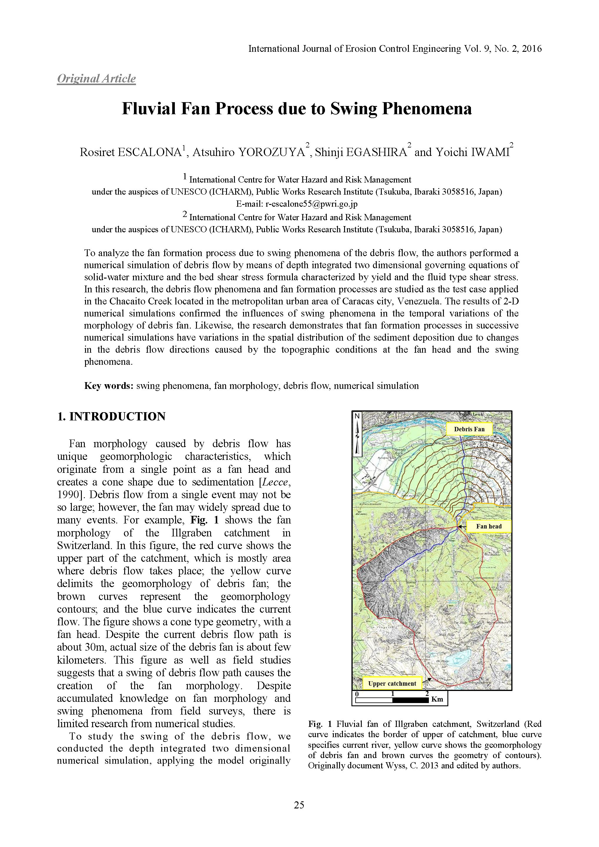
Fluvial Fan Process due to Swing Phenomena
To analyze the fan formation process due to swing phenomena of the debris flow, the authors performed a numerical simulation of debris flow by means of depth integrated two dimensional governing equations of solid-water mixture and the bed shear stress formula characterized by yield and the fluid type shear stress. In this research, the debris flow phenomena and fan formation processes are studied as the test case applied in the Chacaito Creek located in the metropolitan urban area of Caracas city, Venezuela. The results of 2-D numerical simulations confirmed the influences of swing phenomena in the temporal variations of the morphology of debris fan. Likewise, the research demonstrates that fan formation processes in successive numerical simulations have variations in the spatial distribution of the sediment deposition due to changes in the debris flow directions caused by the topographic conditions at the fan head and the swing phenomena.
031
An FAHP-based Quantitative Method for Risk Assessment of Debris-flow Hazards Using Different Fuzzy Numbers
This paper presents the fuzzy analytic hierarchy process (FAHP) for risk assessment of debris-flow occurrence using three different fuzzy numbers. Three layers are involved in the structure of the FAHP: the goal layer, the criteria layer, and the sub-criteria layer. In the criteria and sub-criteria layers, nine major influence factors are grouped into three categories: (1) topological and geological conditions, which includes the influence factors of slope angle, type of deposit, grain size distribution, and surface plants; (2) watershed conditions, which includes effective watershed area and quantity of outflow of sediment; and (3) rainfall conditions, which includes rainfall intensity, duration, and accumulated rainfall. Judgment regarding the relative influence of these factors is based on a nine-level scale used to form the fuzzy reciprocal judgment matrices for evaluating the weighting vectors for each layer. Two cases of debris-flow disasters that occurred in eastern Taiwan were tested using the FAHP; one was a debris flow, and the other a mudslide. The results showed that the proposed FAHP models using the three kinds of fuzzy numbers as well as the associated influence factors and criteria can successfully predict the risk of debris-flow hazard occurrence. Furthermore, the predicted overall risk indices obtained from the FAHP using the three kinds of fuzzy numbers were smaller than those obtained from AHP, but more practical due to consideration of the uncertainty and vagueness involved in natural hazards.
032
Debris Flow Prevention Countermeasures with Urban Inundation in a Multihazard-Environment
Large-scale sediment-related disasters have been increasing in recent years [Uchida et al., 2009; Inoue and Doshida, 2012], such as the deep-seated catastrophic landslides caused by Typhoon Talas (T1112) in the Kii Peninsula, southwest Japan, in 2012. The formation and collapse processes of landslide dams strongly influence water and sediment runoff. When a large-scale landslide dam collapses, the peak discharge of downstream flooding can sometimes become several times as large as the inflow discharge upstream. Such abrupt increases in flow discharge often cause serious disasters in downstream areas. The objective of this study was to support prediction systems for hazards caused by debris flows. We developed a crisis management system to contribute to evacuation decisions and actions by providing information to residents. We adopted Hyper KANAKO as the basic tool of the crisis management system. This system can also provide results of temporal changes such as flow depth and sedimentation depth for the administrator. The time-series images are associated with a world file that responds to geographic information from a 2D topographic model. It is possible to check the simulation results on a GIS as soon as calculations have been performed. In addition to the existing system, we developed functions to reproduce the side-bank erosion caused by landslide dam overtopping. This new system requires setting the height of the landslide dam, the width of the river channel, the initial overflow channel width of the landslide dam, and the numerical constant for side-bank erosion velocity as calculation conditions. The system can display the widening of the overflow channel of the landslide dam caused by overtopping, and analyze a series of phenomena related to flooding from the overtopping erosion of the landslide dam. Moreover this system can assist in developing more effective countermeasures and hazard maps for disaster mitigation.
033
Debris Flow Simulation by Applying the Hyper KANAKO System for Water and Sediment Runoff from Overtopping Erosion of a Landslide Dam
Large-scale sediment-related disasters have been increasing in recent years [Uchida et al., 2009; Inoue and Doshida, 2012], such as the deep-seated catastrophic landslides caused by Typhoon Talas (T1112) in the Kii Peninsula, southwest Japan, in 2012. The formation and collapse processes of landslide dams strongly influence water and sediment runoff. When a large-scale landslide dam collapses, the peak discharge of downstream flooding can sometimes become several times as large as the inflow discharge upstream. Such abrupt increases in flow discharge often cause serious disasters in downstream areas. The objective of this study was to support prediction systems for hazards caused by debris flows. We developed a crisis management system to contribute to evacuation decisions and actions by providing information to residents. We adopted Hyper KANAKO as the basic tool of the crisis management system. This system can also provide results of temporal changes such as flow depth and sedimentation depth for the administrator. The time-series images are associated with a world file that responds to geographic information from a 2D topographic model. It is possible to check the simulation results on a GIS as soon as calculations have been performed. In addition to the existing system, we developed functions to reproduce the side-bank erosion caused by landslide dam overtopping. This new system requires setting the height of the landslide dam, the width of the river channel, the initial overflow channel width of the landslide dam, and the numerical constant for side-bank erosion velocity as calculation conditions. The system can display the widening of the overflow channel of the landslide dam caused by overtopping, and analyze a series of phenomena related to flooding from the overtopping erosion of the landslide dam. Moreover this system can assist in developing more effective countermeasures and hazard maps for disaster mitigation.
034
Influence of Particles Fall Velocity, Archimedean’s Force,and Depth of Debris Flow on a Relationship between Ultimate Density of Debris-Flow Mass and Channel Slope
Based on theoretical studies, ambiguous dependence of ultimate density of debris-flow mass on channel slope (debris flow path) and possibility of discontinuous increase of debris-flow mass density, when critical value of channel slope is exceeded, have been established. This allows to develop methods for calculating changes in characteristics of debris flow as it moves in a mountain valley and on a fan, to assess the effects of confluence of debris flow with surface and (or) underground water feeders, to develop optimal measures to reduce damage caused by debris flows by active impact on the rheological characteristics of debris-flow mass, to assess the risk of economic activity in debris-flow dangerous areas, and to develop optimal measures to reduce damage caused by debris flows.